IMAGES TAKEN NEAR TO
Sutherland Drive, DUMBARTON, G82 3NT
Introduction
This page details the photographs taken nearby to Sutherland Drive, G82 3NT by members of the Geograph project.
The Geograph project started in 2005 with the aim of publishing, organising and preserving representative images for every square kilometre of Great Britain, Ireland and the Isle of Man.

There are currently over 7.5m images from over14,400 individuals and you can help contribute to the project by visiting https://www.geograph.org.uk
Image Map
Images are licensed for reuse under creativecommons.org/licenses/by-sa/2.0
Notes
- Clicking on the map will re-center to the selected point.
- The higher the marker number, the further away the image location is from the centre of the postcode.
Image Listing (58 Images Found)
Images are licensed for reuse under creativecommons.org/licenses/by-sa/2.0
Image
Details
Distance
1
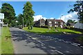
Houses near Barnhill
To some of us, the buildings in this area (at the north-eastern outskirts of Dumbarton) are known informally, on account of their timber cladding, as the Wooden Houses. Argyll Avenue is on the left, with Dumbuck Road branching off to the right.
Image: © Lairich Rig
Taken: 4 Sep 2016
0.06 miles
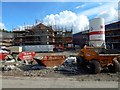
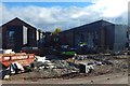
2

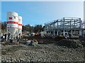
Construction at former site of Crosslet House
A new care home is being built here on the former location of Image The picture was taken from outside the construction site, and shows the northern end of the development.
Image: © Lairich Rig
Taken: 28 Feb 2016
0.07 miles
3
Construction at former site of Crosslet House
Image: © Lairich Rig
Taken: 4 Sep 2016
0.07 miles
4
Construction at former site of Crosslet House
Image: © Lairich Rig
Taken: 4 Sep 2016
0.07 miles
5
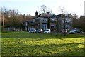
Crosslet House
Crosslet House was built, c.1850, for Sheriff Humphrey Walter Campbell (for more about him and his family, see Image). Before then, the Sheriff had lived at College Park House (which was in the area where Image now stand; see that link for more information). However, when the railway came to Dumbarton, an embankment was created near that house, spoiling the Sheriff's fine view across the Broad Meadow (Image) towards Ben Lomond.
In about 1848, he acquired the Crosslet estate from Alexander Smollett of Bonhill, whose family had owned Crosslet and adjacent Stoneyflat (see below) since about 1700. The Sheriff died at Crosslet in 1864, leaving the property to a relative, John Campbell White (the future Lord Overtoun), who moved there when he married in 1867; White held the tenancy at Crosslet for a number of years, and purchased the estate outright in 1883.
(For the family relationship between Sheriff Humphrey Walter Campbell and John Campbell White, see, again, Image; see also Image)
Following the death of his mother in 1891, John Campbell White moved to Image; he would make many improvements to the Overtoun Estate (for more on his family, see Image and Image).
Peter Denny, son of Dr Peter Denny (see Image), lived at Crosslet House until his death in 1917; Lady Overtoun (the wife of John Campbell White) then moved to Crosslet, staying there until her death in 1931.
Thereafter, Dr J Douglas White (Image), on his very occasional visits to the area (he spent most of his time in London), sometimes occupied the house. He was the nephew of John Campbell White (Lord Overtoun).
Some work on the house took place around 1950. That year saw the formal opening of Crosslet House as a residential nursery; that nursery was closed down in 1974. The building was subsequently put to a variety of uses, but it would ultimately be demolished in the latter part of 2015; a new care home was then built on that site: see, for example, Image, and click on the end-note title for related pictures. For the finished care home, in use, see Image
- - • - -
Roy's Military Survey of Scotland (1740s-50s) shows "Corslet" here. Similarly, the first-edition OS map of c.1860 shows a "Corslet" close to Crosslet, the buildings probably bearing older and newer forms of what is essentially the same place-name.
Some documents from the fifteenth century(*) record the early spelling "Corsflat". The name is similar in form to that of nearby Stoneyflat; perhaps the two names had a similar origin. (Stoneyflat was a farm, located not far to the NNW; it is no longer in existence, its site now being occupied by Dumbarton Cemetery; see http://www.geograph.org.uk/article/Dumbarton-Cemetery#the-location for more details.)
[(*) The spelling "Corsflat" is found in a "retour of service of Humphrey Colquhoun ...", dated 21st June 1479, and in a similar "retour of service of John Colquhoun ...", dated 30th September 1493. The texts are given on pp297-98 and pp304-306, respectively, of the second volume of "The Chiefs of Colquhoun and their Country" (William Fraser, 1869).]
Image: © Lairich Rig
Taken: 9 Jan 2012
0.07 miles
6
Construction at former site of Crosslet House
A new care home is being built here on the former location of Image The picture was taken from outside the construction site, and shows the central to southern part of the development.
Image: © Lairich Rig
Taken: 28 Feb 2016
0.07 miles
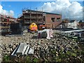
7
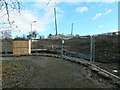
Construction at former site of Crosslet House
The picture shows the construction of a new care home on the former site of Image, which was demolished in 2015.
Image: © Lairich Rig
Taken: 3 Feb 2016
0.08 miles
8
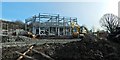
Construction at former site of Crosslet House
A new care home is being built here on the former location of Image The picture was taken from outside the construction site, and shows the southern end of the development (shown from another angle in Image).
Image: © Lairich Rig
Taken: 28 Feb 2016
0.08 miles
9
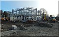
Construction at former site of Crosslet House
A new care home is being built here on the former location of Image The picture was taken from outside the construction site, and shows the southern end of the development (seen from another angle in Image).
Image: © Lairich Rig
Taken: 28 Feb 2016
0.08 miles
10
Construction at former site of Crosslet House
Image: © Lairich Rig
Taken: 23 Oct 2016
0.08 miles