IMAGES TAKEN NEAR TO
Dumbuck Road, DUMBARTON, G82 3AB
Introduction
This page details the photographs taken nearby to Dumbuck Road, G82 3AB by members of the Geograph project.
The Geograph project started in 2005 with the aim of publishing, organising and preserving representative images for every square kilometre of Great Britain, Ireland and the Isle of Man.

There are currently over 7.5m images from over14,400 individuals and you can help contribute to the project by visiting https://www.geograph.org.uk
Image Map
Images are licensed for reuse under creativecommons.org/licenses/by-sa/2.0
Notes
- Clicking on the map will re-center to the selected point.
- The higher the marker number, the further away the image location is from the centre of the postcode.
Image Listing (120 Images Found)
Images are licensed for reuse under creativecommons.org/licenses/by-sa/2.0
Image
Details
Distance
1
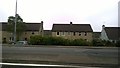
Houses on Dumbuck Road, Dumbarton
Houses on Dumbuck Road in Dumbarton, part of West Dunbartonshire, Scotland. Seen here from Stirling Road. You will notice the "Yes" flyers in the windows for the forthcoming Scottish independence referendum.
Image: © Steven Haslington
Taken: 12 Sep 2014
0.03 miles

3
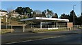
Former garage
This was a garage, and then a vehicle rental centre; it is seen here from the other side of the A82 (compare Image, where part of the same building appears at the far right; my picture was taken from on foot).
By March 2014, the site was again in use: a car wash and takeaway cafe were based there.
The houses in the background are on Mansewood Drive.
Image: © Lairich Rig
Taken: 7 Dec 2012
0.04 miles
4
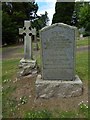
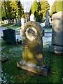
Gravestone of John Orme
This stone marks not only a grave, but also the end of a local tradition: as noted in the inscription, John Orme was "a Dumbarton Worthy, the last of the officially appointed Town Criers, who died 8 December 1904, aged 72. No more crying!"
The stone also commemorates his wife Margaret Maitland (d. 14 May 1909, aged 79), and Dugald Campbell, "Gardener and Philosopher for fifty years in Dumbarton".
An obituary of John Orme appears in the Lennox Herald issue of 24th December 1904. It is signed T.W.; the article provides no further clues to its author's identity (I suspected at first that it might have been written by Tam Watson, who had been Dumbarton's Town Drummer, but, as it happens, Watson had died long before that article was written). Much of what follows is derived from that obituary.
John Orme himself was not sure of his age; at the time of his death, he had been thought to be around 67, but it may be that records later established his age as 72; that is the figure that appears on his gravestone.
Orme occasionally spoke of having worked in Dumbarton's Glassworks in his youth, and it is likely that their closure deprived him of regular employment. The site of the glassworks was later occupied by Denny & Co's Engine Works, and then by Image (also shown in Image).
An 1892 directory lists Orme as a billposter, based at Quay Lane in Dumbarton. While he was posting bills, youngsters would often try to play pranks on him, and he would allow them to get close before he flicked paste at them from his brush. He had not the business acumen to make contracts with large advertisers, and he therefore carried on his work on only a small scale. Nevertheless, he faithfully carried out whatever assignments he was given.
Another of his roles, and one in which he took great pride, was serving as Dumbarton's official Bellman (Town Crier). Though not very clear, his voice was loud, and his messages were understood. It is said that he never forgave the Town Council for abolishing the office of Bellman; the author of the obituary writes that "at best the action was an unkind bit of economy". Though Orme no longer held the official post of Bellman, friends contributed towards the purchase of a new uniform ("regimentals") for him, and of a new and specially inscribed bell.
Orme's third line of work was portering at the train station, in company with two other Dumbarton characters (whom the obituary names only as "S– W–" and "B– the Q–"); in this task he employed a rickety old barrow.
Though without regular paid employment, John Orme worked hard throughout his life, and he was able to keep a roof over his head until the year before his death. When he lost his home, some suggested that he should go to the Poorhouse, but John would not accept this. Instead, he went into lodgings with a certain Paddy Corbett. During this period of his life, a successful benefit concert was held in his behalf. At around the same time, the story circulated that a rich relative of John had died, and that he had therefore come into some wealth; however, it seems that the deceased was a relative of John's wife, and that the couple did not inherit anything.
John Orme had worked hard all his days to avoid the Poorhouse, but in his final days he was laid prostrate by pneumonia, and was taken to the Poorhouse Hospital.
Image: © Lairich Rig
Taken: 27 Jun 2014
0.07 miles
5
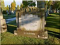
Memorial to Joshua H Wilkinson
"In memoriam Joshua Hardisty Wilkinson, M.A., a brave and noble son, 3 years war service, R.N.V.R., honours student, Glasgow University, died 14th November 1921, aged 24 years, from injuries received at Ibrox Park when playing against the Rangers F.C."
"RNVR": Royal Naval Volunteer Reserve. His parents, who erected the stone, are also commemorated in the inscription.
Joshua went to Dumbarton Academy, where he played in the school's football team. His subsequent studies at Glasgow University were interrupted by the outbreak of the First World War. Joshua joined the Navy; during his three years at sea, he survived being torpedoed. After the war, he resumed his studies at Glasgow University.
He played for Renton Football Club, and then for Dumbarton. In his last match, he was the Dumbarton goalkeeper; after this punishing game (Saturday), he became unwell. On the following Monday, he died in Glasgow's Western Infirmary, after an operation for peritonitis; he had suffered a rupture of the small intestine.
The funeral, on the Thursday, was well attended. Those present included senior and past pupils of Dumbarton Academy, the players and management of Dumbarton FC, and others from outwith the area who had come to pay their respects.
These events are described in much greater detail by Iain Duff at https://iainduff.wordpress.com/2013/11/19/death-of-a-goalkeeper/ (at WordPress).
Image: © Lairich Rig
Taken: 7 Dec 2012
0.09 miles
6
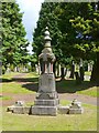
The Oddfellows' Monument
"Loyal Dixon Lodge No. 1901, Dumbarton District of the Independent Order of Oddfellows, M.U., and dedicated to the members of the Past Grand Lodge in trust, 15th September 1900. / Erected by Ex-Bailie George Bell, P.P.G.M. Dumbarton District."
[M.U.: Manchester Unity; P.P.G.M.: Past Provincial Grand Master.]
This particular branch of the Oddfellows was the earliest of the so-called Friendly Societies to appear in the Dumbarton area. It was instituted there in 1839. By 1881, it had a local membership of about 357.
Such organisations might acquire a plot in the cemetery, marked by a monument, to ensure that any of their members who died, and who had been needy or who had no surviving relatives to take care of such matters, might be sure of having a burial place. Compare the Image, located elsewhere in the same cemetery; the accompanying description names similar organisations that had a presence in the district.
Before this memorial was erected, there was already a more prominent landscape feature associated with the Oddfellows: a flagstaff on the top of Dumbuck Hill (this was before quarrying work began eating away at the hill); see Image for more on the flagstaff and the occasion of its presentation.
For more on the George Bell named on this memorial, and for his ancestry, see Image
Image: © Lairich Rig
Taken: 24 Jun 2011
0.09 miles
8

Memorial to Samuel Brewer
The inscription is as follows, including two Biblical quotations:
"Samuel Brewer, Foreman Engineer, with Messrs Denny & Co. Entered into rest 29th Sept'r 1891, aged 69 years. Erected by his fellow workmen in affectionate respect for his memory. / Matilda H Brewer his beloved wife entered into rest 23rd Sept'r 1892, aged 67 years. / My flesh also shall rest in hope. / Be ye therefore ready also, for the Son of Man cometh at an hour when ye think not."
Samuel died in the course of his work, having fallen from a ladder; the fall was not from a very great height, but his head struck an iron block that was lying on the ground.
From "Dumbarton Herald" newspaper, June 8th, 1892: the design was selected from competing entries submitted by Messrs Gilfillan & Co and others. The memorial is 9 feet high as a whole. The base is 3'6" × 1'9". The die (the middle part) is 3' × 3'. The cross is 3' × 2'3".
Image: © Lairich Rig
Taken: 10 Dec 2012
0.10 miles
9
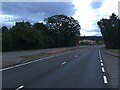
Round Riding Road
The photograph was taken near the eastern end of the road, where it meets the A82, at the foot of Garshake Road.
Round Riding Road follows the same line as a road shown on the first-edition OS map (c.1860), although there were only a few buildings alongside it at that time. The road is not named on that map, but other writings of the time show that it was then called Roundredding Road. Very similar spellings of the name appear on earlier maps from the 1740s to the 1820s (see http://www.geograph.org.uk/article/Dumbarton-Cemetery#the-location for the details).
The Pont/Blaeu map of the Lennox (published in 1654, but based on surveys carried out in the 1580s-90s) shows a "Barundridain" here. That name is presumably the ancestor of the later forms "Roundredding" and "Round Riding".
Returning to what is visible in the photograph, the turning for Kilpatrick View is just ahead, on the left. The escarpment visible in the background is Image The distant area of housing, located on the slopes in front of the escarpment, just left of centre, is the eastern end of Bellsmyre (compare, for example, Image).
On the right, between the pavement and the houses, is a fenced-off area, where a burn flows parallel to the road (and towards the photographer's position). It is not named on the map, but is the Knowle Burn, which had formed the eastern boundary of the medieval burgh.
For a view in the opposite direction along the same road, see Image
Image: © Lairich Rig
Taken: 1 Nov 2011
0.10 miles
10
Dumbarton Cemetery
This picture was taken within the Catholic section of the cemetery. The memorial in the foreground caught my attention because of its carved stonework, but also by virtue of the fact that the inscription is wholly in Latin: PRAECLARIS VIRTUTIBUS PRAEDITA EMMA BRESCIANI ANNOS NATA XXXVI DIE XVI JULII MCMXX IN DOMINO QUIEVIT EUSEBIUM QUADRELLI VIRUM FILIOSQUE PERDOLENTES E SIDERIBUS BENIGNIS RESPICIENS OCULIS.
["Endowed with splendid virtues, Emma Bresciani, on 16 July 1920, at 36 years of age, rested in the Lord, gazing fondly down from the stars upon her grieving husband (Eusebio Quadrelli) and sons."]
Image: © Lairich Rig
Taken: 7 Dec 2012
0.10 miles