IMAGES TAKEN NEAR TO
Birch Road, DUMBARTON, G82 2RE
Introduction
This page details the photographs taken nearby to Birch Road, G82 2RE by members of the Geograph project.
The Geograph project started in 2005 with the aim of publishing, organising and preserving representative images for every square kilometre of Great Britain, Ireland and the Isle of Man.

There are currently over 7.5m images from over14,400 individuals and you can help contribute to the project by visiting https://www.geograph.org.uk
Image Map
Images are licensed for reuse under creativecommons.org/licenses/by-sa/2.0
Notes
- Clicking on the map will re-center to the selected point.
- The higher the marker number, the further away the image location is from the centre of the postcode.
Image Listing (68 Images Found)
Images are licensed for reuse under creativecommons.org/licenses/by-sa/2.0
Image
Details
Distance
1
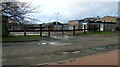
Elm Road Depot
This council depot is located on the western side of Elm Road, in Broadmeadow Industrial Estate.
Image: © Lairich Rig
Taken: 1 Jan 2012
0.05 miles
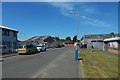
2

Birch Road
The view is from about the same place as Image, but in the opposite direction.
Compare also Image, showing the same stretch of road as the present picture, but in the opposite direction; the tree is a readily identifiable feature of both pictures.
Image: © Lairich Rig
Taken: 1 Jul 2018
0.05 miles
3

Birch Road
This is a view from about halfway along the road. For its northern end, which is ahead, see Image
For the opposite view to the present picture, see Image; the prominent tree is there shown from the other side.
Image: © Lairich Rig
Taken: 1 Jul 2018
0.06 miles
4
Birch Road
The picture was taken near the northern end of the road, which is 40 metres ahead. Compare Image, taken from further back, and Image, taken from the same place as the present picture, but looking in the opposite direction.
Image: © Lairich Rig
Taken: 1 Jul 2018
0.07 miles
5

Leaf galls on Ground-elder
The plants were in the area shown just to the left (north) of the path in Image
These pale yellowish lumps in the leaf-blade of Ground-elder (Aegopodium podagria) are galls caused by the fungus Puccinia aegopodii.
Smaller, dark (but shiny) dots can be seen on some of them; they were much more abundant on the underside. These dark spots might easily be taken for eggs or larvae, but they are telia (singular "telium"), a reproductive structure produced by the fungus. Fungi often produce several distinct kinds of spores, and telia produce a kind known as teliospores.
There were quite a few examples of this gall alongside the path. The identification guide "British Plant Galls" (2ed; Redfern & Shirley, 2011) notes that this gall is "probably common but overlooked".
Image: © Lairich Rig
Taken: 25 May 2018
0.08 miles
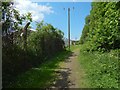
6
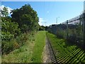
Path to Overburn Avenue
The view is from about 270 metres along the path shown (from its start) in Image; in other words, about two-thirds of the way to Overburn Avenue, as comparison with the 1:25000 map will reveal.
Behind the fence on the right is part of Broadmeadow Industrial Estate, specifically, the part of it between Birch Road and Elm Road (all of the industrial estate's roads are named after trees).
Not much further ahead, the path ends where it meets Overburn Avenue, in the area shown in Image
See Image for a view in the opposite direction.
Image: © Lairich Rig
Taken: 31 Aug 2017
0.08 miles
7
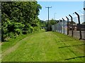
Path to Overburn Avenue
This start of this short route (500 yards long) is signposted at the junction shown in Image; the first part of the path is shown in Image
The photograph was taken from a location about halfway along the path, which ends at the point from which Image was taken. On the right, on the other side of the fence, part of Broadmeadow Industrial Estate is visible.
See Image for a view in the opposite direction.
Image: © Lairich Rig
Taken: 17 Jun 2010
0.08 miles
8
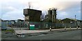
Concrete plant
Tarmac Ltd run this concrete plant, which is located beside Elm Road in Dumbarton's Broadmeadow Industrial Estate. Compare their plant in Greenock: Image
Image: © Lairich Rig
Taken: 1 Jan 2012
0.09 miles
9
Path to the River Leven
Followed in this direction, the path leads from Overburn Avenue to the River Leven, with Broadmeadow Industrial Estate to the left (south) and the course of Dumbarton Golf Club to the right.
See Image and Image for views in the opposite direction.
Image: © Lairich Rig
Taken: 25 May 2018
0.09 miles
10
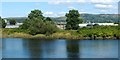
View to Broadmeadow Industrial Estate
The Pont/Blaeu map of the Lennox (based on surveys carried out in the 1580s-90s) shows the town of Dumbarton surrounded on three sides by water. This was no mistake on the part of the mapmakers; the Broad Meadow, an extensive area that is located to the north of the town, and which is now occupied by a large industrial estate and a golf course, was formerly known as the "Drowned Lands", because the area was flooded twice daily by the River Leven, which is tidal here in its lower reaches.
The present-day railway line, on the eastern side of the River Leven, corresponds fairly closely to the southern edge of the area that used to be flooded.
Early in the sixteenth century, a dyke known as the Bishop's water-gang was built to contain the flow, but that dyke fell into disrepair later that century, and the river burst its banks. The result was, as the book "Historic Dumbarton – the Scottish burgh survey" (Dennison/Coleman, 1999) notes, that "some housing was lost, the road to Bonhill disappeared, and Townend became separated from the rest of Dumbarton. Tobias Smollett, a pupil at Dumbarton Grammar School in the 1730s, would recall feeling cobble or paving stones under the water as he paddled the old pathway from the collegiate church to Townend" (for more on Smollett, a local author, see Image and Image).
[A 1609 charter by King James VI refers, in connection with the burgh of Dumbarton, to "the old dyke and water-gang formerly made by umquhile the Bishop of Orkney, and head of the Collegiate Church of said burgh of the time"; this is thought to be a reference to Robert Maxwell of Pollok, who was appointed provost of the Collegiate Church (for which, see Image) in c.1523, and Bishop of Orkney in c.1526. The "dyke and water-gang" was also sometimes referred to as the Bishop's Cast.]
The land would not again be reclaimed until much later. As the work just cited notes, "in the 1850s, the reclaiming of land by the railway company for the Bowling to Balloch Line would mean the draining and embanking of the Broad Meadow".
As this photograph shows, in a view from the other side of the River Leven, Broadmeadow Industrial Estate was later built on the southern part of the meadow, while the northern part was developed into a golf course (see http://www.geograph.org.uk/snippet/1803 for images).
However, the land had not gone entirely unused in the long interval before reclamation in the 1850s. It had been the venue for some sporting events. The book "Dumbarton through the Centuries" (I.M.M.MacPhail, 1972) mentions an advertisement that appeared in the Glasgow Mercury in 1781, for "a horse race to be run on the sands at the Broad Meadow in Dumbarton for a purse of five guineas". The same book also mentions annual regattas at Dumbarton which began in 1830; originally, "the races were rowed round the flooded Broad Meadow at high tide, the finish being opposite the College Bow, where the Central Railway Station now stands". (Image was later moved, more than once.)
The meadow had also been used by drovers; John Mitchell, in an article in issue 76 of the journal "Scottish Local History", mentions that "until the mid-nineteenth century, when the low-lying ground now occupied by the course was embanked against flooding, the drovers brought their animals to the Sands Cattle Fair held on the town's tidal Broad Meadow". As the same author had noted in another article (in issue 61), the Sands Cattle Fair was the successor of the Lammas Cattle Fair that had long been held in the Townhead area; compare Image
Much of the reclaimed land is now occupied by an industrial estate, but a portion was set aside as (and still is) a public park. The following description is taken from Donald MacLeod's "Dumbarton Ancient and Modern" (1893):
"The Meadow Park ... is the oldest ground for recreative purposes in the town. By an Act of Parliament obtained by the burgh in 1857, powers were obtained for the reclamation of the Broad Meadow, which down to and a little beyond that time was covered almost entirely by water twice a day. By the Act the authorities were empowered to set aside a portion of the Meadow as a public park, and they have now devoted 30 acres to this laudable purpose, and a most popular resort the place is. The Common lands of the burgh, of which it forms a part, embraces an area of 140 acres, and the portion of it other than that embraced in the Park is leased to the Dumbarton Golf Club. ... These lands are all that are left to us of the goodly heritage gifted to the community of old time by several kings of Scotland. The burgesses at one time owned the greater portion of the parish of Dumbarton, and a good slice of Bonhill, and thereto hangs a tale the which I will not here recite."
The final sentence of that passage alludes, I think, to losses incurred through gambling.
As for the "goodly heritage" gifted to the community by kings of Scotland, the Golf Course remains, as does the Meadow Park, which is still labelled as such on the map, although it is now better known as Dumbarton Common (Image). Just to the west of the Common, on the opposite side of Townend Road, the area (Image) where there is now a playing field and a bowling green used to be occupied by an ornamental pond. In winter, it could be used as a skating pond. At the end of the nineteenth century, it had a small island with a shelter for swans.
Image: © Lairich Rig
Taken: 15 Aug 2010
0.10 miles