IMAGES TAKEN NEAR TO
Glenpath, DUMBARTON, G82 2QL
Introduction
This page details the photographs taken nearby to Glenpath, G82 2QL by members of the Geograph project.
The Geograph project started in 2005 with the aim of publishing, organising and preserving representative images for every square kilometre of Great Britain, Ireland and the Isle of Man.

There are currently over 7.5m images from over14,400 individuals and you can help contribute to the project by visiting https://www.geograph.org.uk
Image Map
Images are licensed for reuse under creativecommons.org/licenses/by-sa/2.0
Notes
- Clicking on the map will re-center to the selected point.
- The higher the marker number, the further away the image location is from the centre of the postcode.
Image Listing (51 Images Found)
Images are licensed for reuse under creativecommons.org/licenses/by-sa/2.0
Image
Details
Distance
1
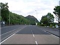
A82 looking to Dumbuck Quarry
In Dumbarton.
Image: © Stephen Sweeney
Taken: 31 May 2008
0.05 miles
2
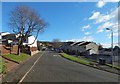
Barnhill Road, Dumbarton
The view is from the area shown in Image; see also Image, from a little further ahead.
An older road to Barnhill survives in the form of a path: https://www.geograph.org.uk/snippet/17320
Image: © Lairich Rig
Taken: 26 Oct 2018
0.07 miles
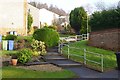
3
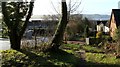
Overtoun House Circular Path
Barnhill Road, visible on the left in this picture, used to follow a different course: Image That part of its former course is now no more than a rough track, but it forms part of a much longer route called Overtoun House Circular Path.
The rough track leads downhill before passing between the two halves of a disused quarry (as shown in Image); the present photograph shows where the circular path (which leads directly away from the photographer's position, in the right-hand side of the picture) joins present-day Barnhill Road. It follows the line of Barnhill Road down to the busy main road (the A82), crosses that road, and then continues along Greenhead Road.
The River Clyde and the area on its far side can be seen in the background.
Image: © Lairich Rig
Taken: 9 Jan 2012
0.08 miles
4
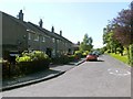
Barnhill Road, Dumbarton
Residential street in the east of the town.
Image: © Stephen Sweeney
Taken: 31 May 2008
0.09 miles
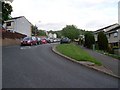
6
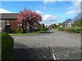
Fourth Avenue, Dumbarton
This is a view from a little further ahead than in Image It shows the junction with Second Avenue.
Image: © Lairich Rig
Taken: 21 Apr 2017
0.09 miles
7
Barnhill Road, Dumbarton
On a steep hillside, hence the steps. A road runs around a loop at the back.
Image: © Richard Webb
Taken: 12 Dec 2015
0.10 miles
9
Fourth Avenue, Dumbarton
The photograph was taken from the junction with Image For a view from a little further ahead, at the junction with Second Avenue, see Image
Image: © Lairich Rig
Taken: 10 Jun 2011
0.10 miles
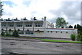
10
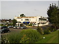
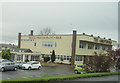
Abbotsford Hotel, Dumbarton
Just off the A82.
Image: © Stephen Sweeney
Taken: 23 Aug 2007
0.11 miles