IMAGES TAKEN NEAR TO
Round Riding Road, DUMBARTON, G82 2HE
Introduction
This page details the photographs taken nearby to Round Riding Road, G82 2HE by members of the Geograph project.
The Geograph project started in 2005 with the aim of publishing, organising and preserving representative images for every square kilometre of Great Britain, Ireland and the Isle of Man.

There are currently over 7.5m images from over14,400 individuals and you can help contribute to the project by visiting https://www.geograph.org.uk
Image Map
Images are licensed for reuse under creativecommons.org/licenses/by-sa/2.0
Notes
- Clicking on the map will re-center to the selected point.
- The higher the marker number, the further away the image location is from the centre of the postcode.
Image Listing (39 Images Found)
Images are licensed for reuse under creativecommons.org/licenses/by-sa/2.0
Image
Details
Distance
1
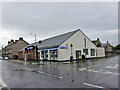
Co-op Funeralcare, Dumbarton
Funeral directors located in Bonhill Road, on the corner of Poindfauld Terrace.
Image: © Richard Dorrell
Taken: 11 Aug 2021
0.03 miles
2
The start of Boghead Road
Image is in the foreground. The nearest house is called Balclutha Lodge; after the death of his first wife, and his subsequent remarriage, nineteenth-century local historian Donald MacLeod (Image) lived there.
Image: © Lairich Rig
Taken: 3 Feb 2017
0.07 miles
3
Bonhill Road, Dumbarton
Looking north, with junction with Alexander Street on the right.
Image: © Richard Dorrell
Taken: 11 Aug 2021
0.08 miles
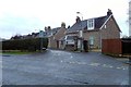
4
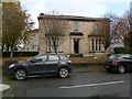
Hartfield House
The building is set at the corner of Bonhill Road (foreground) and Latta Street (on the right). As the sign at the corner indicates, Hartfield House is the Battalion Headquarters of the Argyll and Sutherland Highlanders Battalion Army Cadet Force, The Royal Regiment of Scotland.
See Image for another view of the house, and for details of the building's earlier history.
In the present picture, Image is behind and to the right of the house.
Image: © Lairich Rig
Taken: 18 Oct 2012
0.09 miles
5
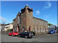
Hartfield House
The building is set on the corner of Latta Street (foreground) and Bonhill Road; see Image for another view, showing the building in context.
The following info is from the cuttings at Dumbarton Library (my thanks to the Local Studies Librarian):
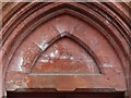
Hartfield House was built sometime around 1853 for William Baird, the Procurator Fiscal of Dumbartonshire. It was sold in 1863 to Andrew McGaan (see Image), a partner in the Dennystown Forge Company, for £1970, and its name was changed to "Annfield". After McGaan's death in 1883, the house was occupied by Colonel John Denny, and the name reverted to Hartfield House. It was taken over by the Territorial Force Association in January 1913.
The picture was therefore taken after close to a century of military use. At present, Hartfield House serves as the Battalion Headquarters of the Argyll and Sutherland Highlanders Battalion Army Cadet Force, The Royal Regiment of Scotland.
Latta Street was named after the tanner Robert Latta; on the family, see Image
Image: © Lairich Rig
Taken: 18 Oct 2012
0.09 miles
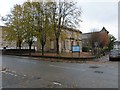
7
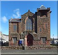
Dumbarton Free High Church
This view shows Image just to the left of the church.
Image: © Lairich Rig
Taken: 10 Apr 2017
0.09 miles
9
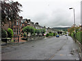
Round Riding Road, Dumbarton
Looking east from close to the junction with Boghead Road.
Image: © Richard Dorrell
Taken: 11 Aug 2021
0.12 miles
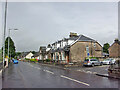
10
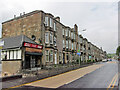
Housing in Bonhill Road, Dumbarton
Looking north from close to the junction with Crosslet Road.
The small shop on the end of the terrace is currently being completely refurbished.
Image: © Richard Dorrell
Taken: 11 Aug 2021
0.13 miles