IMAGES TAKEN NEAR TO
Crosslet Road, DUMBARTON, G82 2ES
Introduction
This page details the photographs taken nearby to Crosslet Road, G82 2ES by members of the Geograph project.
The Geograph project started in 2005 with the aim of publishing, organising and preserving representative images for every square kilometre of Great Britain, Ireland and the Isle of Man.

There are currently over 7.5m images from over14,400 individuals and you can help contribute to the project by visiting https://www.geograph.org.uk
Image Map
Images are licensed for reuse under creativecommons.org/licenses/by-sa/2.0
Notes
- Clicking on the map will re-center to the selected point.
- The higher the marker number, the further away the image location is from the centre of the postcode.
Image Listing (157 Images Found)
Images are licensed for reuse under creativecommons.org/licenses/by-sa/2.0
Image
Details
Distance
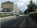
1
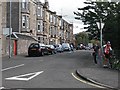
Crosslet Road
Home of Dumbarton Academy. The road is used by National Cycle Route 7
Image: © Richard Webb
Taken: 1 Sep 2009
0.02 miles
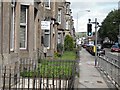
2
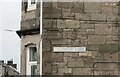
Hartfield Gardens or Crosslet Road?
It appears from the engraved road name in the wall, that when the houses were built, the road here was named Hartfield Gardens, and some maps still show the western end of Crosslet Road as having that name. The very faded more modern name sign reads Crosslet Road.
Image: © Richard Dorrell
Taken: 11 Aug 2021
0.02 miles
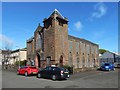
3
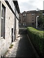
Path between Bonhill Road and Meadow Road
Short cuts an acute junction. There is a shop by the steps on Bonhill Road.
Image: © Richard Webb
Taken: 1 Sep 2009
0.04 miles
4
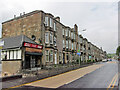
Housing in Bonhill Road, Dumbarton
Looking north from close to the junction with Crosslet Road.
The small shop on the end of the terrace is currently being completely refurbished.
Image: © Richard Dorrell
Taken: 11 Aug 2021
0.04 miles
5
Bonhill Road
Tenements along Bonhill Road. The for sale sign refers to a two bedroom top floor flat being sold for offers over £99,000.
Image: © Richard Webb
Taken: 1 Sep 2009
0.04 miles
6
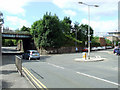
Bonhill Road
The signal box on the right is near Dumbarton Central station.
Image: © Thomas Nugent
Taken: 21 Aug 2010
0.05 miles
7
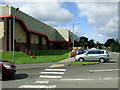
The Meadow Centre
Sports centre near Dumbarton Central station.
Image: © Thomas Nugent
Taken: 21 Aug 2010
0.05 miles
8
Crosslet Road
Viewed from the junction with Bonhill Road.
Image: © Thomas Nugent
Taken: 21 Aug 2010
0.05 miles
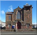
10
Dumbarton Free High Church
This view shows Image just to the left of the church.
Image: © Lairich Rig
Taken: 10 Apr 2017
0.07 miles