IMAGES TAKEN NEAR TO
Allan Place, DUMBARTON, G82 2BJ
Introduction
This page details the photographs taken nearby to Allan Place, G82 2BJ by members of the Geograph project.
The Geograph project started in 2005 with the aim of publishing, organising and preserving representative images for every square kilometre of Great Britain, Ireland and the Isle of Man.

There are currently over 7.5m images from over14,400 individuals and you can help contribute to the project by visiting https://www.geograph.org.uk
Image Map
Images are licensed for reuse under creativecommons.org/licenses/by-sa/2.0
Notes
- Clicking on the map will re-center to the selected point.
- The higher the marker number, the further away the image location is from the centre of the postcode.
Image Listing (56 Images Found)
Images are licensed for reuse under creativecommons.org/licenses/by-sa/2.0
Image
Details
Distance
1
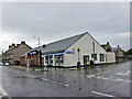
Co-op Funeralcare, Dumbarton
Funeral directors located in Bonhill Road, on the corner of Poindfauld Terrace.
Image: © Richard Dorrell
Taken: 11 Aug 2021
0.06 miles
2
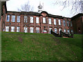
Braehead Primary School
On a brae overlooking Meadow Park.
Image: © Thomas Nugent
Taken: 18 Mar 2011
0.08 miles
3

Braehead Primary School
A traditional Dumbarton School Board building on Meadow Road.
Image: © Thomas Nugent
Taken: 18 Mar 2011
0.08 miles
4
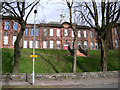
Braehead Primary School
Overlooking Meadow Park.
Image: © Thomas Nugent
Taken: 18 Mar 2011
0.08 miles
5
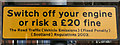
Traffic sign
On Meadow Road, at Braehead Primary School.
Image: © Thomas Nugent
Taken: 18 Mar 2011
0.08 miles
6
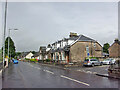
Bonhill Road, Dumbarton
Looking north, with junction with Alexander Street on the right.
Image: © Richard Dorrell
Taken: 11 Aug 2021
0.09 miles
7
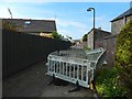
Path to Chapelton Avenue
The path had recently been resurfaced, as is revealed by comparison with two earlier pictures, one taken during work on gas infrastructure, and the other after that work was finished: Image / Image
Image: © Lairich Rig
Taken: 22 Mar 2020
0.11 miles
8
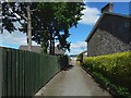
Path to Chapelton Avenue
The view is as in Image, but after the works shown there were complete. The path was later resurfaced: Image
Image: © Lairich Rig
Taken: 21 Jun 2018
0.11 miles
9
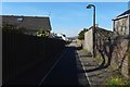
Path to Chapelton Avenue
Work was taking place on gas infrastructure. The view is from where the path leaves Bonhill Road. For a later view, after the completion of the work, see Image
Image: © Lairich Rig
Taken: 18 May 2018
0.11 miles
10
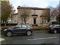
Hartfield House
The building is set on the corner of Latta Street (foreground) and Bonhill Road; see Image for another view, showing the building in context.
The following info is from the cuttings at Dumbarton Library (my thanks to the Local Studies Librarian):
Hartfield House was built sometime around 1853 for William Baird, the Procurator Fiscal of Dumbartonshire. It was sold in 1863 to Andrew McGaan (see Image), a partner in the Dennystown Forge Company, for £1970, and its name was changed to "Annfield". After McGaan's death in 1883, the house was occupied by Colonel John Denny, and the name reverted to Hartfield House. It was taken over by the Territorial Force Association in January 1913.
The picture was therefore taken after close to a century of military use. At present, Hartfield House serves as the Battalion Headquarters of the Argyll and Sutherland Highlanders Battalion Army Cadet Force, The Royal Regiment of Scotland.
Latta Street was named after the tanner Robert Latta; on the family, see Image
Image: © Lairich Rig
Taken: 18 Oct 2012
0.12 miles