IMAGES TAKEN NEAR TO
Crosslet Road, DUMBARTON, G82 2AJ
Introduction
This page details the photographs taken nearby to Crosslet Road, G82 2AJ by members of the Geograph project.
The Geograph project started in 2005 with the aim of publishing, organising and preserving representative images for every square kilometre of Great Britain, Ireland and the Isle of Man.

There are currently over 7.5m images from over14,400 individuals and you can help contribute to the project by visiting https://www.geograph.org.uk
Image Map
Images are licensed for reuse under creativecommons.org/licenses/by-sa/2.0
Notes
- Clicking on the map will re-center to the selected point.
- The higher the marker number, the further away the image location is from the centre of the postcode.
Image Listing (28 Images Found)
Images are licensed for reuse under creativecommons.org/licenses/by-sa/2.0
Image
Details
Distance
1
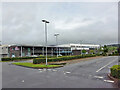
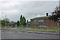
Dumbarton Academy
Viewed from just inside the vehicle entrance from Crosslet Road.
The Academy is a West Dunbartonshire Council non-denominational secondary school with a roll of approximately 600 pupils.
Image: © Richard Dorrell
Taken: 11 Aug 2021
0.03 miles
2
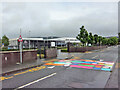
Colourful speed hump
Located outside an entrance to Dumbarton Academy, this speed hump in Crosslet Road doubles as a crossing place for pedestrians.
Image: © Richard Dorrell
Taken: 11 Aug 2021
0.08 miles
3
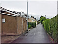
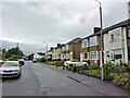
Boghead Road, Dumbarton
This stretch of Boghead Road in suburban Dumbarton is very narrow and has no pedestrian pavement. Nevertheless, the road is the sole access to a number of residential properties.
Image: © Richard Dorrell
Taken: 11 Aug 2021
0.09 miles
4
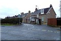
St Patrick's Primary School, Dumbarton
Located adjacent to Dumbarton Academy in Crosslet Road, St Patrick's is a West Dunbartonshire Council Roman Catholic primary school with a current roll of approximately 360 pupils.
Image: © Richard Dorrell
Taken: 11 Aug 2021
0.09 miles
5
Eastern end of Boghead Road
Looking north-west from the cul-de-sac end of this residential road in suburban Dumbarton.
Image: © Richard Dorrell
Taken: 11 Aug 2021
0.10 miles
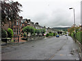
6
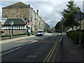
Crosslet Road
Viewed from the junction with Bonhill Road.
Image: © Thomas Nugent
Taken: 21 Aug 2010
0.14 miles
7
The start of Boghead Road
Image is in the foreground. The nearest house is called Balclutha Lodge; after the death of his first wife, and his subsequent remarriage, nineteenth-century local historian Donald MacLeod (Image) lived there.
Image: © Lairich Rig
Taken: 3 Feb 2017
0.14 miles
8
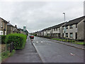
Crosslet Road, Dumbarton
Housing towards the eastern end of the road.
Image: © Richard Dorrell
Taken: 11 Aug 2021
0.14 miles
9
Round Riding Road, Dumbarton
Looking east from close to the junction with Boghead Road.
Image: © Richard Dorrell
Taken: 11 Aug 2021
0.15 miles