IMAGES TAKEN NEAR TO
Meadowbank Street, DUMBARTON, G82 1SB
Introduction
This page details the photographs taken nearby to Meadowbank Street, G82 1SB by members of the Geograph project.
The Geograph project started in 2005 with the aim of publishing, organising and preserving representative images for every square kilometre of Great Britain, Ireland and the Isle of Man.

There are currently over 7.5m images from over14,400 individuals and you can help contribute to the project by visiting https://www.geograph.org.uk
Image Map (Loading...)


Getting Data...Please wait
Leaflet Map data © OpenStreetMap
Images are licensed for reuse under creativecommons.org/licenses/by-sa/2.0
Notes
- Clicking on the map will re-center to the selected point.
- The higher the marker number, the further away the image location is from the centre of the postcode.
Image Listing (421 Images Found)
Images are licensed for reuse under creativecommons.org/licenses/by-sa/2.0
Image
Details
Distance
1
Glasgow Road
The subject is as in Image, but the view is from further ahead. The cattle market mentioned in that item was ahead, just to the left of the road, at the bend, where some trees overhang the pavement.
Image: © Lairich Rig
Taken: 27 Oct 2017
0.02 miles
2
Beside Glasgow Road
At the time of writing (mid-2020), maps show a place of worship (named Dumbarton Baptist Church at larger scales) here; it was located in the low white building seen ahead, but c.2016 the building was sold and became a kitchen showroom.
Image: © Lairich Rig
Taken: 1 Jun 2020
0.03 miles
3
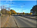
Glasgow Road, Dumbarton (A814)
The A814 diverges from the A82 close to the Dumbuck Quarry near Milton. It heads west through the eastern suburbs of Dumbarton as Glasgow Road.
Image: © David Dixon
Taken: 26 Sep 2019
0.04 miles
4
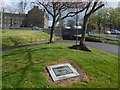
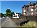
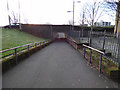
Paths leading to an underpass
The underpass leads below Glasgow Road. The sign above its entrance points out the location of the Registrar's Office, which is in the Image (visible on the right, behind the yellow grit bin, in the present picture).
The plaque in the foreground records regeneration work carried out here in 2003. The art on it depicts, in relation to present-day structures, a pattern of agricultural furrows, thought to date from the 13th century, that was discovered when a car park, out of shot to the left, was being extended.
Image: © Lairich Rig
Taken: 25 Apr 2016
0.05 miles
5
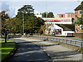
Glasgow Road underpass
Links the town centre and the railway station.
Image: © Thomas Nugent
Taken: 5 Jan 2017
0.05 miles
6
Risk Street tenements
Viewed from College Way.
Image: © Thomas Nugent
Taken: 5 Jan 2017
0.05 miles
7
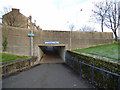
Glasgow Road underpass
Links the town centre with the railway station.
Image: © Thomas Nugent
Taken: 5 Jan 2017
0.05 miles
8
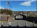
Heading under the railway line
Station Road is on this side, Bankend Road on the other.
Image: © Lairich Rig
Taken: 8 Aug 2020
0.06 miles
9
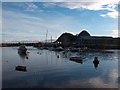
River Leven, Dumbarton
The River Leven, Dumbarton, on a late autumn afternoon with Dumbarton Rock in the background.
Image: © Andrew McEwan
Taken: 27 Nov 2005
0.06 miles
10
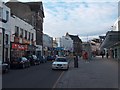
Dumbarton High Street.
Dumbarton High Street. In the middle distance is the Glencairn Greit (Great) House, 1623, once home to the Earls of Glencairn and then the Dukes of Argyll.
It is flanked on its left by the provincial Art Deco premises of the former Burton's tailors (1937-38).
Image: © Andrew McEwan
Taken: 27 Nov 2005
0.06 miles