IMAGES TAKEN NEAR TO
High Street, DUMBARTON, G82 1NB
Introduction
This page details the photographs taken nearby to High Street, G82 1NB by members of the Geograph project.
The Geograph project started in 2005 with the aim of publishing, organising and preserving representative images for every square kilometre of Great Britain, Ireland and the Isle of Man.

There are currently over 7.5m images from over14,400 individuals and you can help contribute to the project by visiting https://www.geograph.org.uk
Image Map
Images are licensed for reuse under creativecommons.org/licenses/by-sa/2.0
Notes
- Clicking on the map will re-center to the selected point.
- The higher the marker number, the further away the image location is from the centre of the postcode.
Image Listing (432 Images Found)
Images are licensed for reuse under creativecommons.org/licenses/by-sa/2.0
Image
Details
Distance
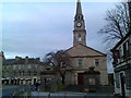
1
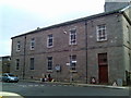
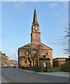
Dumbarton Riverside Parish Church
This old church building sits at the bottom of Church Street. The spire is not visible in this picture.
Image: © Stephen Sweeney
Taken: 25 Nov 2007
0.01 miles
2
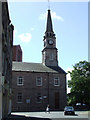
Riverside Parish Church
At the junction of Church Street, High Street and Castle Street. See also Image
Image: © Thomas Nugent
Taken: 21 Aug 2010
0.01 miles
3
Dumbarton Riverside Parish Church
For more information, see Image
Image: © Lairich Rig
Taken: 4 Dec 2016
0.01 miles
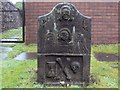
4
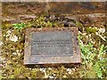
Plaque at the site of John Aroll's gravestone
This plaque is one of several that are located at the foot of a wall alongside a narrow and probably seldom-visited lane (visible on the left, behind a gate, in Image) behind the church halls of Image The plaques indicate the positions of some old gravestones that have been placed, and almost entirely buried, at the foot of the wall; for a discussion of the location, and of the other stones to be found here, see http://www.geograph.org.uk/article/Dumbarton-Cemetery#the-parish-churchyard
The text on this plaque is rather terse:
"JOHN AROLL (Schoolmaster Rhu)
Died 2nd February 1760 Aged 52
John Aroll was murdered."
The original stone is also located here, but is largely buried to preserve it. Only its very top can be seen; in this picture, the top of the stone can be seen at the base of the wall, right behind the plaque, partly covered in moss. The other old stones that are set along this wall (click on the end-note title and look for the memorials to John Bell, Captain James Lang, and William McAlla) have likewise been partly buried. The inscription on the original stone cannot be seen, but reads as follows (with original quirks of spelling retained):
"Here lyes the body of John Aroll, shoolmaster of Row, who died febuar the 2, 1760. Aged 52 years. Omnibus est Odio, Crudelitas et simulatio Repugnat Amicitie."
[The part in Latin means "cruelty is hateful to all, and insincerity is repugnant to friendship". Row is an older spelling of the place-name Rhu (Image). For an illustration of the gravestone, see Donald MacLeod's "Dumbarton Ancient & Modern" (1893).]
The story behind the gravestone is recounted by Dr I M M MacPhail in "Dumbarton through the Centuries"; the story can also be found in Donald MacLeod's book, cited above.
Aroll had gone to Dumbarton to collect the then very considerable debt of £30 from a man named Cunningham, who, after obtaining a receipt from Aroll, killed him, and took back the money. For a while, Cunningham concealed the body in a disused chimney, but he later threw it into the River Leven under cover of darkness.
There was, at the time, a superstitious belief that if a murderer touched his victim's body, then the latter would bleed (this was called "ordeal by touch"). Cunningham was a chief suspect when Aroll's body was found, but, when asked to touch the corpse, he refused, claiming to believe that the corpse would bleed because he (Cunningham) had shaved on a Sunday. In response, the parish minister pointed out that he himself had occasionally shaved on a Sunday, and that he had touched the corpse without causing it to bleed. Nevertheless, Cunningham managed to evade justice for the rest of his life, confessing only on his deathbed.
Image: © Lairich Rig
Taken: 4 Apr 2009
0.01 miles
5
The gravestone of Janet McIntyre
This gravestone is located beside a path leading around the eastern side of the church hall of Image
For views of the church as a whole, see Image, Image (where part of the church hall is visible at the left), and Image The medieval parish church stood on the same spot, at the junction of the Kirk Vennel (now Image) and the High Street (still so called).
According to the book "Dumbarton through the centuries" (I.M.M.MacPhail, 1972), "it was dedicated to St Mary and is first mentioned in a charter of 1320 ... The present parish church was built in 1811, replacing a building which, from its appearance in Paul Sandby's picture of 1747, probably dated from the fourteenth or fifteenth century".
The burial ground around the church used to be considerably larger, but was diminished in several stages. For the details of this process, and of the history of the parish churchyard as a whole, and for a view of some of the other old stones that survive here, see http://www.geograph.org.uk/article/Dumbarton-Cemetery#the-parish-churchyard
The stone shown in the present photograph caught my attention, not only because of the carvings on its near side, but also because it appears to be one of the oldest of the visible stones in the burial ground.
It also seems to be a typical example of those mentioned by Donald MacLeod in his book "The God's Acres of Dumbarton" (1888); writing at a time when there were many more stones in the burial ground, MacLeod commented that "there are a good many quaint, upright, grey old tombstones scattered through the Churchyard, having as ornamentation death's-heads and cross-bones, hour-glasses, hideously ugly winged cherubic heads – one of the number being further adorned with a tailor's goose and scissors. These stones date principally from the early part of the eighteenth century".
[The artwork on the gravestones may not have been entirely to MacLeod's liking, but it is fairly typical of stones from that period, and is no better or worse than on those found elsewhere.]
The stone shown here bears the initials "P H" and "J M". The inscription on the other side is as follows, where I have preserved the original spelling and line divisions (the stone is slightly chipped at one of the upper corners; hence the missing letter at the end of the first line):
"HERE LYES THE COR[P]
S OF IANET McKNT
YRE SPOUSE TO PAT
RICK HOUSTOUNE W
HO DYED NOV 7 1721"
Image: © Lairich Rig
Taken: 31 Dec 2010
0.01 miles
6
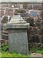
Memorial to Archibald McMillan
This stone is located at the south-eastern corner of the old kirkyard of Image
If the monument shown here is the original one, then most of it is now buried (the old churchyard contains other stones that are now largely buried, e.g., Image). The original is described as being about ten feet high. In addition, it was originally "surmounted by a beautifully-carved casket adorned with Greek ornaments". The inscription is as follows:
"Archibald McMillan (Shipbuilder)
Died 27th December 1854 Aged 61
Wife Catherine Smith
Children,
Peter, died 21st January 1828,
aged 2 years 3 months,
Peter, died 20th May 1833, aged 5."
The person commemorated here was the founder of the shipbuilding firm of Archibald McMillan and Son, which was established in 1834 at a site upriver from Image See Image for further details of the founding of the firm, and for references. The firm later relocated to a site next to Dumbarton Parish Kirkyard (in which the memorial is located; click on the end-note title for related images).
In 1910, McMillan was granted permission to buy part of that kirkyard (which had by then been closed to burials for many years), thereby expanding his shipyard at its expense. The shipyard closed in 1930, and its site was next occupied by a distillery, only remnants of which survive at the time of writing: Image
Archibald's wife Catherine was originally from Luss (Image), and she was buried beside the church at West Bridgend (Image). Archibald's son John McMillan, along with Peter Denny, presented Levengrove Park as a gift to the town and people of Dumbarton: http://www.geograph.org.uk/snippet/5911
[For further biographical details, and for details of the memorial, see Donald MacLeod's "The God's Acres of Dumbarton" (1888).]
Image: © Lairich Rig
Taken: 16 Apr 2011
0.01 miles
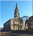
7
Facade and spire of Riverside Parish Church
Viewed from High Street.
Image: © Stephen Sweeney
Taken: 25 Nov 2007
0.01 miles
8
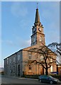
Dumbarton Riverside Parish Church
For a wider view, with more context, see Image
For a selection of other contributors' pictures of the building, see Image / Image / Image / Image / Image The present photograph was taken just a few minutes before sunset; the moon can be seen to the right of the steeple.
A good source of information on this church is the booklet "Dumbarton Parish Church in History", originally by Edward McGhie, and revised and enlarged by David Wilson; it contains a great deal more information than the present item.
The authors note that there is likely to have been a parish church at the time when Dumbarton was erected a Royal Burgh by Alexander II in 1222; they suggest that it was probably similar in size and form to the ancient parish church of Cardross, whose ruins can still be seen in Levengrove Park: http://www.geograph.org.uk/snippet/5737
Any such small building was superseded by the medieval church, which stood in the same place as the present church. It is depicted in a sketch of 1747 by Paul Sandby; from its appearance in that sketch, which is a view of the parish church from the south-east, it is thought to have displayed architectural features typical of the fourteenth or fifteenth century; it has been noted that the building, as depicted in the sketch, with its squat steeple, is similar to the still-extant St Monan's Church (Image) in Fife; see, for example, Image
Dumbarton Parish Church is known to have been enlarged in the seventeenth century to give a T-shaped plan. Sandby's sketch also shows, beside the north-eastern corner of the church, the unfinished Buchanan Hospital, on which more will be said below. The sketch also shows various gravestones in the kirkyard: some upright stones, and quite a few table-top stones.
As far as documentary evidence goes, the first mention of the Parish Church is in a charter of 1320 by King Robert the Bruce; in that charter, Robert transfers his right of patronage of the church to Kilwinning Abbey. The first mention of the church in Dumbarton's burgh records dates from 1372.
The medieval church is described (in its post-Reformation state, with various altars removed) by Dumbarton's early historian John Glen, in his 1847 "History of the Town and Castle of Dumbarton". For a time, until 1761, the town's Grammar School appears to have been based in a vaulted chamber under the steeple.
The building of a new church was proposed in 1810. The architect was John Brash, whose first design was rejected as too large and elaborate. The authors of "Dumbarton Parish Church in History" note the similarity of the final design of the church, as shown in the present photograph, to that of Image, which was also designed by Brash. The present-day Dumbarton Parish Church was opened by the minister James Oliphant on the 28th of July 1811 (Oliphant's own gravestone is nearby, in an enclosure adjoining the eastern end of the kirkyard: Image).
At the time of writing, the church is known as Dumbarton Riverside Parish Church.
According to the architectural description given in "The Buildings of Scotland: Stirling and Central Scotland" (John Gifford and Frank Arneil Walker; 2002), the gate-piers (Image) date from 1813, and the illuminated clock dials, by JB Joyce & Co of Whitchurch, Shropshire, were mounted in 1901 – see Image (The book actually says "J.T.Joyce", a minor slip that I have corrected here.)
- - • - -
The kirkyard associated with the church used to be more extensive, but it has been diminished in several stages, most notably in the 1970s, when much of what remained of the kirkyard was cleared away to make space for the present-day church halls. Before that happened, the memorials with legible inscriptions were photographically recorded.
Only a small number of the original memorials now remain, although Image and the Barnhill Vault (now containing Image and Image) survive to this day; they were legally considered as being separate from the kirkyard proper. The history of the kirkyard and of its reduction in size, and the various controversies that arose in connection with this, have been discussed at length in a separate article – http://www.geograph.org.uk/article/Dumbarton-Cemetery#the-parish-churchyard – and that information need not be repeated here.
For pictures of some of the remaining memorials, click on the end-note title, below.
- - • - -
As for the Buchanan Hospital that was mentioned above, no traces remain above ground, although it is possible that some buried traces survive under or near the present-day church halls. The building extended eastwards from the north-eastern corner of the parish church, and it is depicted, in an unfinished state, in Paul Sandby's sketch of 1747.
There are references in Dumbarton's Burgh Records from as early as 1630 regarding preparations for building the hospital, which was to be endowed by the Laird of Buchanan (Sir John Buchanan). For example, an entry from 25 June of that year describes difficulties in getting materials unloaded at the shore: "the staines that ar to be caryit be boit to the kirk yaird for the bigging of the hospital can not weill win to for the heiht of the sand". An entry of 13 May 1634 records that the work was to be discontinued until certain difficulties could be resolved with the Laird of Buchanan.
There appear to have been some financial problems; an entry for 14 May 1635 speaks of the Provost being urged to "tak the best cours he can for getting that thousand pund awand to the hospitall be umqu[hill] Sir George Elphinstoune". An entry for 18 January 1636 records that obstacles to beginning the work had been removed: "the Laird of Buchanane writes that staine, lyme, sand, and uthir materialls for the hospitall ar reddie, q[uhe]rby the maissons may entir the first of Marche", although the same entry notes that money was still owed, with "Law to be put into exec[utio]n againe Drumakill for that thousand punds, and againe him and Fulwood his cau[tio]n[e]r for aucht hunder merks awand to the hospitall".
The hospital was endowed with £1021, and entrusted to the care of the Kirk Session and the Town Council, but it is unclear whether it was ever completed or occupied. In any case, the houses in Beggar Row (now long gone) on Castle Street were built using its debris [Donald Macleod in "Dumbarton Ancient and Modern"].
In the 1650s, the Burgh's Common Good Accounts note several payments of interest on a sum of 800 pounds owed to the hospital and kirk session; more specifically, payment was to go to the "poores box". The Buchanan Mortification Fund, as it came to be known, continued to be used for poor relief. "In 1655, the Town Council had decided to use part of the money, given by Sir John Buchanan for a hospital, for the maintenance of another minister, and the interest of the rest for poor relief" ["Dumbarton Common Good Accounts, 1614-1660", note 6 on page 221].
Donald MacLeod devotes pages 42 and 43 of his 1884 work "Dumbarton, Vale of Leven, and Loch Lomond" to a discussion of the "Alms-House and Hospital": "This building, which stood immediately to the east of the Parish Church, is supposed to have been erected in either the 14th or 15th century" (he appears to be speaking here of the Alms-house as something distinct from the hospital, since he goes on to say that "it was the Laird of Buchanan who erected the hospital" in 1636). MacLeod adds, regarding the Alms-house, that names of donors, and the amounts of their donations, were displayed on painted boards hung along the walls of the Parish Church, Buchanan of Auchmar being the principal contributor. He states that in 1759, stones from the building (by then a ruin) were used to build a bridge over the "Gallow Mollen/Mollan" (MacLeod appears to view this as another name for the now largely culverted Knowle Burn, also sometimes called the Mill Burn; it formed the eastern boundary of the medieval burgh of Dumbarton). He then discusses the Buchanan Hospital, and the circumstances that led to its funds becoming reduced; he says that the original documents relating to this fund are lost, having last been read, as far as is known, on the 9th of January 1786.
Image: © Lairich Rig
Taken: 18 Jan 2013
0.02 miles
9
Dumbarton Riverside Parish Church
This view is intended to show the church in context, in the High Street. For a closer look, and for the main description, see Image; other photographs of the building are linked from there.
Click on the end-note title for related images, including surviving memorials in the kirkyard.
Of the two large gate-piers beside the entrance, only the one on the left is fully in view in the present picture. In the 1950s, the space under that gate-pier was not empty as it now is, but was occupied by a drinking fountain of the kind that was often to be seen at the time on streets and in parks; no trace of that drinking fountain can now be seen.
For a view of the two large gate-piers from the other side, see Image Another contributor's earlier photograph is very similar to the present picture: Image
Image: © Lairich Rig
Taken: 18 Jan 2013
0.02 miles
10
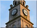
Dumbarton Riverside Parish Church: detail
For a view of the building as a whole, and for the main description of the church, see Image A reference work cited there states that the illuminated clock dials were mounted in 1901; they are by the venerable Shropshire clockmaking firm JB Joyce & Co.
Image: © Lairich Rig
Taken: 18 Jan 2013
0.02 miles