IMAGES TAKEN NEAR TO
Bruce Street, DUMBARTON, G82 1HX
Introduction
This page details the photographs taken nearby to Bruce Street, G82 1HX by members of the Geograph project.
The Geograph project started in 2005 with the aim of publishing, organising and preserving representative images for every square kilometre of Great Britain, Ireland and the Isle of Man.

There are currently over 7.5m images from over14,400 individuals and you can help contribute to the project by visiting https://www.geograph.org.uk
Image Map
Images are licensed for reuse under creativecommons.org/licenses/by-sa/2.0
Notes
- Clicking on the map will re-center to the selected point.
- The higher the marker number, the further away the image location is from the centre of the postcode.
Image Listing (135 Images Found)
Images are licensed for reuse under creativecommons.org/licenses/by-sa/2.0
Image
Details
Distance
1
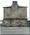
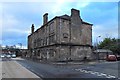
End wall, Grange Place
The wall faces Bruce Street; the front of the building faces Glasgow Road. The plaque on the wall commemorates the Dumbarton Building Society. See Image for a view from Glasgow Road and for more information.
Image: © Richard Sutcliffe
Taken: 1 Sep 2023
0.02 miles
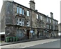
2
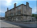
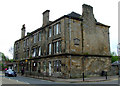
Grange Place, Glasgow Road, Dumbarton
This block, at the corner of Glasgow Road and Bruce Street, was built by Dumbarton Building Society, as a plaque, visible on the wall on the right, bears witness; for its inscription, see Image
The text "Erected 1906" originally followed those words; it will be seen from the picture of the inscription that there is the appearance of something's having been removed from just below it.
The name Grange Place also appears on these buildings, both as incised lettering and on a faded sign, located near the other inscription, but just round the corner, on the side facing Glasgow Road.
For a view with a little more context, see Image
265 metres to the east, a house on Image also has a Dumbarton Building Society stone built into it; the stone serves mainly to commemorate the Society's Jubilee in 1923, but it also indicates that the buildings on the west side of Silverton Avenue were built in that year. For the stone itself, see Image
Image: © Lairich Rig
Taken: 24 Jan 2018
0.02 miles
3
Grange Place, Glasgow Road, Dumbarton
For a view from a little closer, see Image; that item has more information about the year in which the block was built, and some comments on the inscription on its side.
The present picture is intended to provide more context; the bridge in the left background is beside Image; see also Image, which includes part of Grange Place on the right.
The bridge is also shown from this side in Image, and from the other side in Image and (an older picture) Image
Image: © Lairich Rig
Taken: 24 Jan 2018
0.03 miles
4
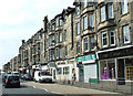
Glasgow Road Dumbarton
Near the Bruce Street junction.
Image: © Thomas Nugent
Taken: 12 Jul 2013
0.03 miles
5
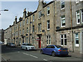
Knoxland Square
Tenements on the north side of the square.
See Image for details of the history of the square.
Image: © Thomas Nugent
Taken: 12 Jul 2013
0.03 miles
6
Tenement on Glasgow Road
Beside Dumbarton East railway station. See the plaque on the side of the building here Image
Image: © Thomas Nugent
Taken: 24 Apr 2011
0.03 miles
7

Dumbarton Building Society plaque
On the Bruce Street side of this tenement building on Glasgow Road Image
Image: © Thomas Nugent
Taken: 24 Apr 2011
0.03 miles
8
Grange Place
On Glasgow Road, opposite Dumbarton East Station. See Image for a different view and more information.
Image: © Richard Sutcliffe
Taken: 1 Sep 2023
0.03 miles