IMAGES TAKEN NEAR TO
Old Academy Way, DUMBARTON, G82 1AY
Introduction
This page details the photographs taken nearby to Old Academy Way, G82 1AY by members of the Geograph project.
The Geograph project started in 2005 with the aim of publishing, organising and preserving representative images for every square kilometre of Great Britain, Ireland and the Isle of Man.

There are currently over 7.5m images from over14,400 individuals and you can help contribute to the project by visiting https://www.geograph.org.uk
Image Map
Images are licensed for reuse under creativecommons.org/licenses/by-sa/2.0
Notes
- Clicking on the map will re-center to the selected point.
- The higher the marker number, the further away the image location is from the centre of the postcode.
Image Listing (367 Images Found)
Images are licensed for reuse under creativecommons.org/licenses/by-sa/2.0
Image
Details
Distance
1
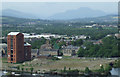
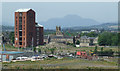
Remains of Ballantine's distillery
With the River Leven in the foreground and Ben Lomond in the distance.
Image: © Thomas Nugent
Taken: 12 Jul 2013
0.02 miles
2
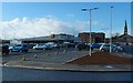
New supermarket
Image: © Lairich Rig
Taken: 26 Feb 2020
0.02 miles
3
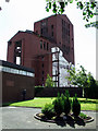
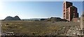
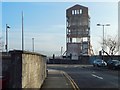
Red brick towers
All that remains of the former Dumbarton distillery. Viewed from Riverside Parish Churchyard.
Image: © Thomas Nugent
Taken: 21 Aug 2010
0.03 miles
4
Red brick towers
The remains of Dumbarton Distillery, as seen from Riverside Lane.
Image: © Thomas Nugent
Taken: 21 Aug 2010
0.03 miles
5
Remains of Ballantine's distillery
Only the central tower of what was at one time the largest distillery in the world remains. Ben Lomond can be seen in the distance.
Viewed from Bower Battery at Dumbarton Castle.
Image: © Thomas Nugent
Taken: 12 Jul 2013
0.03 miles
6
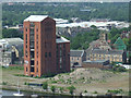
The former site of Ballantine's Distillery
Of the distillery buildings, only a single tower now remains; see Image for another view, for further details, and for links to related images.
Before the distillery was built, this had been the site of McMillan's Shipyard: Image
The picture was taken from Image Dumbarton Rock is visible in the background: http://www.geograph.org.uk/snippet/203
Image: © Lairich Rig
Taken: 21 Feb 2013
0.03 miles
7
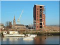
Remains of Ballantine's distillery
On the east bank of the River Leven. Viewed from the top of Dumbarton Rock.
Image: © Thomas Nugent
Taken: 12 Jul 2013
0.03 miles
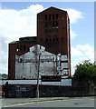
8
Ballantine's Distillery brick tower during demolition
The brick tower, the Image, was being demolished when the present picture was taken; compare Image, taken about seven weeks earlier, before demolition was under way.
For a closer view of the tower, from that side of the Leven, a few days later, see Image, which shows demolition work being carried out.
Image: © Lairich Rig
Taken: 21 Jan 2017
0.03 miles
9
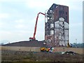
Ballantine's Distillery brick tower being demolished
Though made of brick, the structure is reinforced by steel girders. For an indication of the rapid progress of demolition, see:
Image (4 days later),
Image (7 days later),
Image (11 days later).
For other related pictures, click on the end-note title.
Image: © Lairich Rig
Taken: 23 Jan 2017
0.03 miles
10
Ballantine's Distillery brick tower during demolition
The view is from Riverside Lane. The tower is greatly reduced as compared with its appearance in Image, although that picture was taken only 22 days earlier; the removal of the building, though it had long been delayed, proceeded quickly.
See Image and linked pictures for a sequence of images showing the progress of demolition.
For the construction that later took place on the cleared site, see Image
Image: © Lairich Rig
Taken: 27 Jan 2017
0.03 miles