IMAGES TAKEN NEAR TO
Scots Terrace, DUMBARTON, G82 1AH
Introduction
This page details the photographs taken nearby to Scots Terrace, G82 1AH by members of the Geograph project.
The Geograph project started in 2005 with the aim of publishing, organising and preserving representative images for every square kilometre of Great Britain, Ireland and the Isle of Man.

There are currently over 7.5m images from over14,400 individuals and you can help contribute to the project by visiting https://www.geograph.org.uk
Image Map
Images are licensed for reuse under creativecommons.org/licenses/by-sa/2.0
Notes
- Clicking on the map will re-center to the selected point.
- The higher the marker number, the further away the image location is from the centre of the postcode.
Image Listing (184 Images Found)
Images are licensed for reuse under creativecommons.org/licenses/by-sa/2.0
Image
Details
Distance
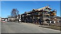
1
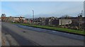
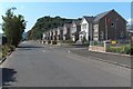
Castle Point development under construction
Castle Road is in the foreground.
Image: © Lairich Rig
Taken: 21 Nov 2016
0.00 miles
2
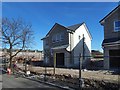
Castle Point development under construction
Image: © Lairich Rig
Taken: 26 Mar 2017
0.02 miles
3
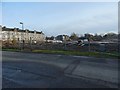
Castle Point development under construction
The view is across Castle Road. The houses in the left background are on Castlegreen Street.
Image: © Lairich Rig
Taken: 21 Nov 2016
0.03 miles
4
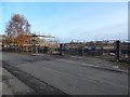
Castle Point development under construction
The gates are a reminder of the former use of the site by Allied Distillers: see Image As noted there, the Blackburn Aircraft Factory had earlier occupied the same site.
Image: © Lairich Rig
Taken: 21 Nov 2016
0.03 miles
5
Castle Point development under construction
Image: © Lairich Rig
Taken: 26 Mar 2017
0.03 miles
6
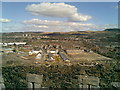
View from the castle
Looking NE up Victoria Street. Whisky warehouses no longer exist with new development on left and nothing (yet) on the right.
Image: © tony ferrie
Taken: 14 Apr 2008
0.03 miles
8
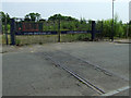
Railway tracks crossing Castle Road
Traces of when this area was heavily industrialised. This was the site of the Blackburn Aircraft Works http://canmore.rcahms.gov.uk/en/site/89047/details/dumbarton+castle+road+blackburn+aircraft+works/ . The tracks led to the docks which were once located behind the photographer, but are now a housing estate.
Image: © Thomas Nugent
Taken: 12 Jul 2013
0.04 miles
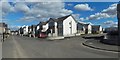
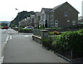
9
Castle Road
This is a view along Castle Road. Dumbarton Rock, with some of the buildings of Dumbarton Castle, can be seen at its far end.
The nearer buildings are part of Image, as is the road branching off to the right, which is called Denny Road (the Denny family were prominent in the local shipbuilding industry; see http://www.geograph.org.uk/article/Dumbarton-Cemetery#shipbuilding-and-other-industries for further details).
See also Image / Image / Image
Image: © Lairich Rig
Taken: 26 Jun 2009
0.04 miles
10
Castle Road
Leading to Dumbarton Rock and Dumbarton Castle.
Image: © Thomas Nugent
Taken: 12 Jul 2013
0.04 miles