IMAGES TAKEN NEAR TO
Old Mill Court, CLYDEBANK, G81 6BE
Introduction
This page details the photographs taken nearby to Old Mill Court, G81 6BE by members of the Geograph project.
The Geograph project started in 2005 with the aim of publishing, organising and preserving representative images for every square kilometre of Great Britain, Ireland and the Isle of Man.

There are currently over 7.5m images from over14,400 individuals and you can help contribute to the project by visiting https://www.geograph.org.uk
Image Map
Images are licensed for reuse under creativecommons.org/licenses/by-sa/2.0
Notes
- Clicking on the map will re-center to the selected point.
- The higher the marker number, the further away the image location is from the centre of the postcode.
Image Listing (52 Images Found)
Images are licensed for reuse under creativecommons.org/licenses/by-sa/2.0
Image
Details
Distance
1
Corner of Roman Road and Milton Douglas Road
Roman Road in Duntocher is possibly the oldest road in Clydebank, and is believed to cross the oldest bridge in Scotland.
Image: © Stephen Sweeney
Taken: 24 Jul 2008
0.03 miles
2
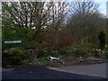
Old Mill Road
By the Duntocher Burn.
Image: © Stephen Sweeney
Taken: 5 Apr 2009
0.05 miles
3
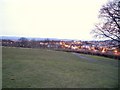
Dusk view across Clydebank
Taken from the top of the trig station in Goldenhill Park. The line of lights in the centre distance are the Erskine Bridge.
Image: © Stephen Sweeney
Taken: 9 Apr 2008
0.09 miles
4
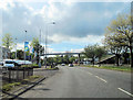
A82 west passing Arnold Clark motor dealers
Footbridge can be seen crossing road
Image: © John Firth
Taken: 12 May 2012
0.11 miles
5
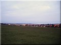
Goldenhill Park
And a fine view across Clydebank and Erskine.
Image: © Stephen Sweeney
Taken: 9 Apr 2008
0.11 miles
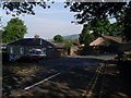
6
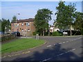
Mallard Road, Duntocher
Just off Milton Douglas Road.
Image: © Stephen Sweeney
Taken: 24 Jul 2008
0.12 miles
8
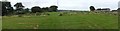
Site of Roman Fort on Antonine Wall
This spot, near the summit of Golden Hill in Duntocher, was the site of one of the forts of the Antonine Wall. The remains of the fort are not currently exposed, but the grass has been cut in such a way as to show the outlines of the structures that once stood here.
The Antonine Wall was (except at its eastern end) a turf rampart built upon a stone base. Only a few metres from the point at which this photo was taken, part of the stone base of the wall is exposed, although protected by railings: Image
The fort at Duntocher is discussed in the book "A Guide to the Roman Remains in Britain" (Roger J.A.Wilson, 1980): "... a gate here leads to Golden Hill and a railed-off portion of Wall-base .... Excavations on top of the hill in 1948-51 revealed that an Antonine fortlet preceded a very small fort here .... The fortlet had been demolished and replaced by the fort even before the actual Wall was built in this sector, and it may be presumed that the latter was built from east to west. The same conclusion was reached when the terminal fort at Old Kilpatrick, now built over, was excavated in 1923-4 and 1931".
The fort encloses only 0.2 hectares, making it the smallest of the known forts on the Wall. According to the World Heritage Site Nomination Document for the Antonine Wall (written by Prof. David Breeze), the original plan had been for just six forts (these are now called primary forts) along the line of the Wall, but it was later decided to add secondary forts (of which Golden Hill is one) to reduce the average distance between forts to about 3.6 km.
When the Nomination Document was published (in 2007), the remains of sixteen forts survived, as well as nine fortlets, along with some smaller enclosures and "expansions" (whose function is currently unclear). The bid was successful: the Antonine Wall is now listed as a World Heritage Site.
Situated centrally in the background is a flagstaff that stands at the summit of Golden Hill, which is located within Goldenhill Park.
Image: © Lairich Rig
Taken: 18 Sep 2009
0.14 miles
9
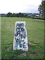
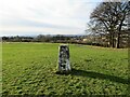
Duntocher trig point
This graffiti daubed trig point is in a park on the former site of Roman fort.
Image: © Mark Nightingale
Taken: 13 Sep 2006
0.14 miles