IMAGES TAKEN NEAR TO
CLYDEBANK, G81 5QP
Introduction
This page details the photographs taken nearby to G81 5QP by members of the Geograph project.
The Geograph project started in 2005 with the aim of publishing, organising and preserving representative images for every square kilometre of Great Britain, Ireland and the Isle of Man.

There are currently over 7.5m images from over14,400 individuals and you can help contribute to the project by visiting https://www.geograph.org.uk
Image Map
Images are licensed for reuse under creativecommons.org/licenses/by-sa/2.0
Notes
- Clicking on the map will re-center to the selected point.
- The higher the marker number, the further away the image location is from the centre of the postcode.
Image Listing (32 Images Found)
Images are licensed for reuse under creativecommons.org/licenses/by-sa/2.0
Image
Details
Distance
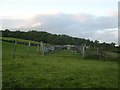
1
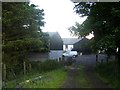
West Muirhouses
From the path to the north which leads to Jaw Reservoir.
Image: © Stephen Sweeney
Taken: 20 Jun 2008
0.01 miles
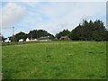
2
West Muirhouses
Farm on the outskirts of Clydebank.
Image: © Stephen Sweeney
Taken: 20 Jun 2008
0.01 miles
3
West Muirhouses
Farm and house [The Eyrie], seen from the path from East Muirhouses to Jaw Reservoir.
Image: © M J Richardson
Taken: 31 Aug 2023
0.02 miles
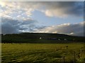
6
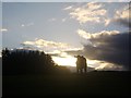
Silhouetted bull
In a field by East Muirhouses.
Image: © Stephen Sweeney
Taken: 20 Jun 2008
0.12 miles
7
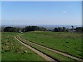
Path to West Muirhouses
From Jaw Reservoir.
Image: © Stephen Sweeney
Taken: 18 Apr 2009
0.12 miles
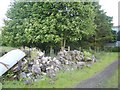
9
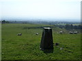
Trig point next to East Muirhouses
229m trig point overlooking Glasgow and the River Clyde.
Image: © Chris Upson
Taken: 4 Sep 2005
0.14 miles
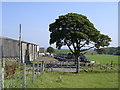
10
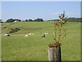
Tree growing out of a gatepost
West Muirhouses Farm in the background
Image: © Chris Upson
Taken: 4 Sep 2005
0.14 miles