IMAGES TAKEN NEAR TO
Waulking Mill Road, CLYDEBANK, G81 5AJ
Introduction
This page details the photographs taken nearby to Waulking Mill Road, G81 5AJ by members of the Geograph project.
The Geograph project started in 2005 with the aim of publishing, organising and preserving representative images for every square kilometre of Great Britain, Ireland and the Isle of Man.

There are currently over 7.5m images from over14,400 individuals and you can help contribute to the project by visiting https://www.geograph.org.uk
Image Map
Images are licensed for reuse under creativecommons.org/licenses/by-sa/2.0
Notes
- Clicking on the map will re-center to the selected point.
- The higher the marker number, the further away the image location is from the centre of the postcode.
Image Listing (44 Images Found)
Images are licensed for reuse under creativecommons.org/licenses/by-sa/2.0
Image
Details
Distance
1
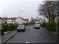
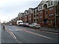
Waulking Mill Road, Faifley
From Faifley Road.
Image: © Stephen Sweeney
Taken: 12 Apr 2008
0.07 miles
2
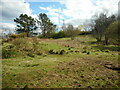
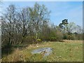
Grassland, Auchnacraig Woodland Park
One of several open areas within the park.
Image: © Richard Sutcliffe
Taken: 15 Apr 2023
0.09 miles
3
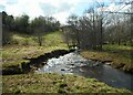
Cochno Burn
Flowing through Auchnacraig Woodland Park. The flats on the horizon are on Auchnacraig Road.
Image: © Richard Sutcliffe
Taken: 15 Apr 2023
0.10 miles
4
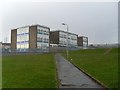
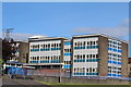
Edinbarnet Primary School
In Faifley.
Image: © Stephen Sweeney
Taken: 12 Apr 2008
0.10 miles
6
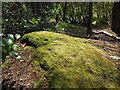
Cup-marked boulder
There are three stones in this area with cup-and-ring marks, as indicated on the 1:25000 map. The two more northerly stones are shown in Image; the present picture shows the other stone, the southernmost one of the group. Even though this is not a particularly close view, some cup marks are still plainly visible.
Image: © Lairich Rig
Taken: 21 Apr 2014
0.12 miles
7
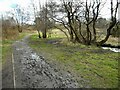
Muddy path
Most of the paths at Auchnacraig Woodland Park are good, but this section is particularly muddy.
Image: © Richard Sutcliffe
Taken: 15 Apr 2023
0.12 miles
8
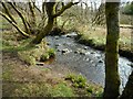
Cochno Burn
Flowing through Auchnacraig Woodland Park.
Image: © Richard Sutcliffe
Taken: 15 Apr 2023
0.12 miles
9
Faifley Road flats
Roughly opposite Edinbarnet Primary School.
Image: © Stephen Sweeney
Taken: 12 Apr 2008
0.12 miles
10
Cup-and-ring-marked rocks
As indicated on the 1:25000 map, there is a group of stones here with cup-and-ring marks. There are three stones in the group: the two more northerly stones of the group form a close pair, shown in this photograph: one of the pair is clearly visible in the foreground, while the other one is directly behind it, at the edge of the woods. The third stone, the southernmost one of the group, stands a little apart from the other two; it is off to the left, among the trees (a link to a picture of it is given below).
The Canmore report linked from the end-note describes the three stones. The latter part (1951/1966) of that report calls the stones A, B and C. In the present picture, stone B appears in the foreground, with stone A directly behind it.
Stone A details: Image / Image
Stone B details: Image
Stone C is the southerly one, not shown in the present picture, but out of shot to the left, among the trees. It is shown in Image
Image: © Lairich Rig
Taken: 21 Apr 2014
0.13 miles