IMAGES TAKEN NEAR TO
Ellinger Court, CLYDEBANK, G81 4PB
Introduction
This page details the photographs taken nearby to Ellinger Court, G81 4PB by members of the Geograph project.
The Geograph project started in 2005 with the aim of publishing, organising and preserving representative images for every square kilometre of Great Britain, Ireland and the Isle of Man.

There are currently over 7.5m images from over14,400 individuals and you can help contribute to the project by visiting https://www.geograph.org.uk
Image Map
Images are licensed for reuse under creativecommons.org/licenses/by-sa/2.0
Notes
- Clicking on the map will re-center to the selected point.
- The higher the marker number, the further away the image location is from the centre of the postcode.
Image Listing (101 Images Found)
Images are licensed for reuse under creativecommons.org/licenses/by-sa/2.0
Image
Details
Distance
1
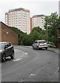
Towerblocks, Burnside Court
Seen from Durban Avenue.
Image: © Richard Sutcliffe
Taken: 29 Jul 2018
0.01 miles
2

Tower block and fountain
The tower block is Burneside Court. The fountain Image is within Dalmuir Park and dates from 1907.
Image: © Richard Sutcliffe
Taken: 21 Jan 2022
0.04 miles
3
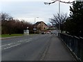
Mountblow Road at Dumbarton Road
Mountblow Road connects Dumbarton Road with the A82, and is the main access from Clydebank for the Erskine Bridge.
Image: © Stephen Sweeney
Taken: 9 Apr 2008
0.04 miles
4

Car wash & valeting centre
A taxi get a wash at the car wash & valeting centre on Dumbarton Road.
Image: © Richard Sutcliffe
Taken: 21 Jan 2022
0.04 miles
5

Train in siding
The train had just arrived in the siding, having come from Dalmuir Station. The tower block on the right is Burnside Court.
Image: © Richard Sutcliffe
Taken: 21 Jan 2022
0.05 miles
6
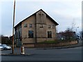
Dalmuir Barclay Church
Recent church, constructed in the early 1990s, after the union of Dalmuir Overtoun and Old Kilpatrick Barclay.
Image: © Stephen Sweeney
Taken: 9 Apr 2008
0.06 miles
8

The pond, Dalmuir Park
A flock of black-headed gulls are making good use of the pond. It was originally the mill dam for the adjacent paper mill owned by the Collins family, who also owned Dalmuir House, in the grounds of which the park was laid out in 1906.
West Court, on Littleholm Place is reflected in the water.
Image: © Richard Sutcliffe
Taken: 21 Jan 2022
0.08 miles
9

Missing corner tenement
The corner of Dumbarton Road and Burns Street. A very large number of properties in Clydebank were damaged or destroyed in the Clydebank Blitz of 13-15 March 1941. This corner property was probably one of the many casualties.
Image: © Richard Sutcliffe
Taken: 21 Jan 2022
0.08 miles
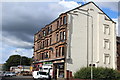
10
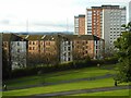
Tenements and tower blocks
Different designs of housing. Sandstone tenements from the early 20th century and high-rise flats from the late 20th century.
Seen from Dalmuir Park. The railway line to Dumbarton and Helensburgh runs between the tenements and the park.
Image: © Richard Sutcliffe
Taken: 21 Jan 2022
0.08 miles