IMAGES TAKEN NEAR TO
Myrtle Road, CLYDEBANK, G81 4NY
Introduction
This page details the photographs taken nearby to Myrtle Road, G81 4NY by members of the Geograph project.
The Geograph project started in 2005 with the aim of publishing, organising and preserving representative images for every square kilometre of Great Britain, Ireland and the Isle of Man.

There are currently over 7.5m images from over14,400 individuals and you can help contribute to the project by visiting https://www.geograph.org.uk
Image Map
Images are licensed for reuse under creativecommons.org/licenses/by-sa/2.0
Notes
- Clicking on the map will re-center to the selected point.
- The higher the marker number, the further away the image location is from the centre of the postcode.
Image Listing (61 Images Found)
Images are licensed for reuse under creativecommons.org/licenses/by-sa/2.0
Image
Details
Distance
1
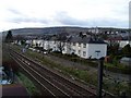
Looking to Mountblow from Mountblow Road
Across Laurel Avenue in the foreground, to Mountblow House and Adelaide Court in the distance.
Image: © Stephen Sweeney
Taken: 9 Apr 2008
0.03 miles
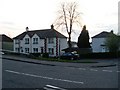
3
Salisbury Place, Mountblow
This part of Salisbury Place, just off Mountblow Road, is a much better quality build than the majority of the housing in the street.
Image: © Stephen Sweeney
Taken: 9 Apr 2008
0.07 miles
4
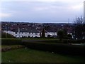
View to Dalmuir West from Mountblow
Erskine can be seen off in the distance as well - most notably the Bridgewater shopping centre.
Image: © Stephen Sweeney
Taken: 9 Apr 2008
0.09 miles
5
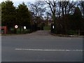
Entrance to Dalmuir Park
The entrance off Mountblow Road.
Image: © Stephen Sweeney
Taken: 9 Apr 2008
0.10 miles
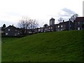
6
Corner of Mountblow Road and Salisbury Place, Dalmuir
Image: © Alan Reid
Taken: 8 Jan 2017
0.10 miles
7

Weir on the Duntocher Burn
The semi-circular weir dates back to the time when there used to be a paper mill here. The bridge on the right forms one of the entrances to Dalmuir Park.
Image: © Richard Sutcliffe
Taken: 21 Jan 2022
0.11 miles
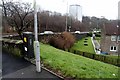
8

Duntocher Burn
Seen from the bridge at the Mountblow Road entrance to Dalmuir Park.
Image: © Richard Sutcliffe
Taken: 21 Jan 2022
0.11 miles
9

Weir, Duntocher Burn
The semi-circular weir dates back to the time when there used to be a paper mill here.
Image: © Richard Sutcliffe
Taken: 21 Jan 2022
0.11 miles
10

Weir and bridge over the Duntocher Burn
The semi-circular weir dates back to the time when there used to be a paper mill here. The bridge forms one of the entrances to Dalmuir Park.
Image: © Richard Sutcliffe
Taken: 21 Jan 2022
0.11 miles