IMAGES TAKEN NEAR TO
Laurel Avenue, CLYDEBANK, G81 4NP
Introduction
This page details the photographs taken nearby to Laurel Avenue, G81 4NP by members of the Geograph project.
The Geograph project started in 2005 with the aim of publishing, organising and preserving representative images for every square kilometre of Great Britain, Ireland and the Isle of Man.

There are currently over 7.5m images from over14,400 individuals and you can help contribute to the project by visiting https://www.geograph.org.uk
Image Map
Images are licensed for reuse under creativecommons.org/licenses/by-sa/2.0
Notes
- Clicking on the map will re-center to the selected point.
- The higher the marker number, the further away the image location is from the centre of the postcode.
Image Listing (61 Images Found)
Images are licensed for reuse under creativecommons.org/licenses/by-sa/2.0
Image
Details
Distance
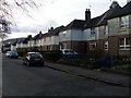
1
Looking to Mountblow from Mountblow Road
Across Laurel Avenue in the foreground, to Mountblow House and Adelaide Court in the distance.
Image: © Stephen Sweeney
Taken: 9 Apr 2008
0.04 miles
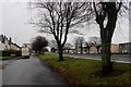
2
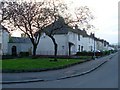
Canberra Avenue housing
Quiet residential street in Dalmuir West.
Image: © Stephen Sweeney
Taken: 20 Apr 2009
0.06 miles
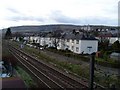
4

Railway line west of Dalmuir
The line goes to Dumbarton and Helensburgh. The road running alongside the line is Laurel Avenue.
Image: © Richard Sutcliffe
Taken: 21 Jan 2022
0.07 miles
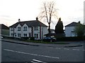
5
Housing on Dumbarton Road
In Dalmuir West.
Image: © Stephen Sweeney
Taken: 9 Apr 2008
0.08 miles

7
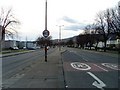
Dumbarton Road, Dalmuir West
Dual carriageway going from Old Kilpatrick to Clydebank.
Image: © Stephen Sweeney
Taken: 9 Apr 2008
0.10 miles
9
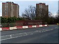
Barriers on the bridge over the railway at Mountblow Road
These barriers have been here for as long as I can remember! A common sight around Greater Glasgow. I believe it's to do with money - the councils believe the railway companies should pay for the repairs to the bridges, and vice versa. As a result, these barriers sit on the bridges for many years.
Image: © Stephen Sweeney
Taken: 9 Apr 2008
0.12 miles
10

Weir on the Duntocher Burn
The semi-circular weir dates back to the time when there used to be a paper mill here. The bridge on the right forms one of the entrances to Dalmuir Park.
Image: © Richard Sutcliffe
Taken: 21 Jan 2022
0.12 miles