IMAGES TAKEN NEAR TO
Burns Street, CLYDEBANK, G81 4BN
Introduction
This page details the photographs taken nearby to Burns Street, G81 4BN by members of the Geograph project.
The Geograph project started in 2005 with the aim of publishing, organising and preserving representative images for every square kilometre of Great Britain, Ireland and the Isle of Man.

There are currently over 7.5m images from over14,400 individuals and you can help contribute to the project by visiting https://www.geograph.org.uk
Image Map
Images are licensed for reuse under creativecommons.org/licenses/by-sa/2.0
Notes
- Clicking on the map will re-center to the selected point.
- The higher the marker number, the further away the image location is from the centre of the postcode.
Image Listing (159 Images Found)
Images are licensed for reuse under creativecommons.org/licenses/by-sa/2.0
Image
Details
Distance
1

Burns Street
The street leads to the railway line at the end.
Image: © Richard Sutcliffe
Taken: 21 Jan 2022
0.02 miles
2
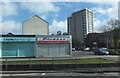
Commercial premises and high-rise housing
Alongside Dumbarton Road (A814) in Dalmuir.
Image: © Barbara Carr
Taken: 18 Apr 2013
0.04 miles
3
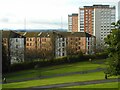
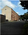
Tenements and tower blocks
Different designs of housing. Sandstone tenements from the early 20th century and high-rise flats from the late 20th century.
Seen from Dalmuir Park. The railway line to Dumbarton and Helensburgh runs between the tenements and the park.
Image: © Richard Sutcliffe
Taken: 21 Jan 2022
0.04 miles
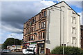
4

Missing corner tenement
The corner of Dumbarton Road and Burns Street. A very large number of properties in Clydebank were damaged or destroyed in the Clydebank Blitz of 13-15 March 1941. This corner property was probably one of the many casualties.
Image: © Richard Sutcliffe
Taken: 21 Jan 2022
0.05 miles
5

Flats on Dumbarton Road
At the corner with Pattison Street
Image: © Richard Sutcliffe
Taken: 21 Jan 2022
0.05 miles
6
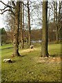
Mature trees
There are some areas of mature woodland within the park, dating from around 1910. A few trees have recently been felled. The park's pond can be seen in the distance.
Image: © Richard Sutcliffe
Taken: 21 Jan 2022
0.05 miles
8
Dunn Street, Dalmuir
Red sandstone tenements on a quiet street.
Image: © Richard Sutcliffe
Taken: 1 Sep 2023
0.07 miles
9
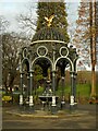
The Fountain, Dalmuir Park
The fountain was installed in Dalmuir Park in 1907 as a gift from an ex-Provost, Samuel Leckie. It was built in the McFarlane's Saracen Foundry in Possilpark, Glasgow. The coat of arms of the Burgh of Clydebank is one of several images high on the fountain. The other 'heads' of lions, gryphons, owls and the eagle were typical features of ornate ironwork made in the early 20th century. (Notice in Dalmuir Park)
Image: © Richard Sutcliffe
Taken: 21 Jan 2022
0.07 miles
10

The Currie Memorial
Memorial to Robert Currie, who died trying to save a child Image
Image: © Richard Sutcliffe
Taken: 21 Jan 2022
0.07 miles