IMAGES TAKEN NEAR TO
Mountblow Road, CLYDEBANK, G81 4BD
Introduction
This page details the photographs taken nearby to Mountblow Road, G81 4BD by members of the Geograph project.
The Geograph project started in 2005 with the aim of publishing, organising and preserving representative images for every square kilometre of Great Britain, Ireland and the Isle of Man.

There are currently over 7.5m images from over14,400 individuals and you can help contribute to the project by visiting https://www.geograph.org.uk
Image Map
Images are licensed for reuse under creativecommons.org/licenses/by-sa/2.0
Notes
- Clicking on the map will re-center to the selected point.
- The higher the marker number, the further away the image location is from the centre of the postcode.
Image Listing (39 Images Found)
Images are licensed for reuse under creativecommons.org/licenses/by-sa/2.0
Image
Details
Distance
1
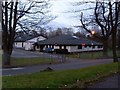
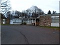
Kilpartick School, Building B
Special learning school in Mountblow.
Image: © Stephen Sweeney
Taken: 9 Apr 2008
0.05 miles
2
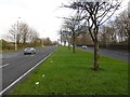
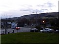
Great Western Road
View towards Glasgow from the central reservation.
Image: © Richard Webb
Taken: 4 Jan 2016
0.10 miles
3
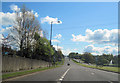
Mountblow road junction with A82
Just east of flyover viewed towards Glasgow
Image: © John Firth
Taken: 12 May 2012
0.10 miles
4

Road sign on the A82
Approaching the Mountblow Road junction.
Image: © Stephen Sweeney
Taken: 11 May 2009
0.11 miles
5
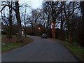
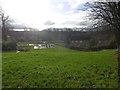
Road to Auchentoshan
This road just off Mountblow Road is not named - the buildings on it are addressed as Mountblow Road.
Image: © Stephen Sweeney
Taken: 9 Apr 2008
0.12 miles
6

Carleith Primary School
School in Duntocher, by the A82.
Image: © Stephen Sweeney
Taken: 11 May 2009
0.12 miles
7
Park and play area, Duntocher
Between Dalgleish Avenue and Stark Avenue.
Image: © Richard Webb
Taken: 4 Jan 2016
0.13 miles
8
Auchentoshan Adult Training Centre
Helps adults with learning disabilities.
Image: © Stephen Sweeney
Taken: 9 Apr 2008
0.14 miles
9
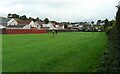
Outskirts of Duntocher
Some of the houses at the western end of Duntocher. Seen from beside the Thomas Wood Path.
Image: © Richard Sutcliffe
Taken: 1 Oct 2021
0.14 miles
10
Slip road to A82 Trunk road
From Mountblow Road.
Image: © Stephen Sweeney
Taken: 9 Apr 2008
0.15 miles