IMAGES TAKEN NEAR TO
Dalmuir Court, CLYDEBANK, G81 4AA
Introduction
This page details the photographs taken nearby to Dalmuir Court, G81 4AA by members of the Geograph project.
The Geograph project started in 2005 with the aim of publishing, organising and preserving representative images for every square kilometre of Great Britain, Ireland and the Isle of Man.

There are currently over 7.5m images from over14,400 individuals and you can help contribute to the project by visiting https://www.geograph.org.uk
Image Map
Images are licensed for reuse under creativecommons.org/licenses/by-sa/2.0
Notes
- Clicking on the map will re-center to the selected point.
- The higher the marker number, the further away the image location is from the centre of the postcode.
Image Listing (173 Images Found)
Images are licensed for reuse under creativecommons.org/licenses/by-sa/2.0
Image
Details
Distance
1

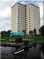
Dalmuir Court
Tower block overlooking the Dalmuir Drop Lock on the Forth and Clyde Canal.
Image: © Richard Sutcliffe
Taken: 21 Jan 2022
0.01 miles
2
Tower block off Duntocher Road
Newly painted with a Noblet dust cart passing on the Duntocher Road. The Dalmuir drop lock in the foreground. It lowers the waterlevel in a pit under the Dumbarton Road, thus getting over the problem of cleaning up after planners who built roads through, rather than over canals they thought would never reopen.
Image: © Richard Webb
Taken: 1 Sep 2009
0.01 miles
3
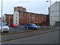
Tenements in Dalmuir
On Stewart Street and Swindon Street.
Image: © Stephen Sweeney
Taken: 9 Apr 2008
0.02 miles
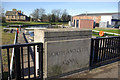
4
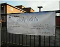
Banner on the railings
A banner inviting people to 'Worship with Us'. The Redeemed Christian Church of God Lighthouse for all Nations is one of the organizations who use the Dalmuir Community Centre (in the background).
Image: © Richard Sutcliffe
Taken: 21 Jan 2022
0.03 miles
5

Dalmuir Community Centre
On Duntocher Road.
Image: © Richard Sutcliffe
Taken: 21 Jan 2022
0.04 miles
6
Garage, Dumbarton Road
View from the drop lock on the Forth and Clyde Canal. This was the first time I saw new petrol and diesel prices after a 2p fuel tax rise. It was a bit of a shock as the previous day's price back in East Lothian was around £1.02 per litre. Here it was £1.15.
Soon found out that this was an anomalous price, and running at about 10p a litre more expensive than other filling stations in the area.
Image: © Richard Webb
Taken: 1 Sep 2009
0.04 miles
7

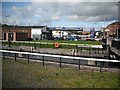
A variety of housing types
Looking from Duntocher Road.
Image: © Richard Sutcliffe
Taken: 21 Jan 2022
0.04 miles
8
Dumbarton Road Bridge, Dalmuir
Carrying Dumbarton Road across Dalmuir Drop Lock on the Forth and Clyde Canal.
Image: © Stephen McKay
Taken: 19 Mar 2008
0.04 miles
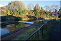
9

Dalmuir Drop Lock
The Forth and Clyde Canal is crossed by the A814, Dumbarton Road (seen on the left). When originally built there was a swing bridge here, but this was removed after the canal had gone out of use. With the revival of the canal a new solution was required to allow boats on the canal to negotiate the crossing.
The answer was the first drop lock to be constructed in the UK. A large lock chamber was built under the road bridge. Boats enter the lock, the lock gates are closed behind them. They then wait until water is pumped out to lower the level enough for them to pass under the roadway. Once they are on the other side the water is pumped back in, the lock gates on the other end are opened and the boat can proceed.
This photograph replicates the first image for the square Image photographed and submitted in 2005.
Image: © Richard Sutcliffe
Taken: 21 Jan 2022
0.04 miles
10
Turf zone DropLock
Lock on the Forth and Clyde Canal.
Image: © Ian S
Taken: 11 Nov 2023
0.04 miles