IMAGES TAKEN NEAR TO
Betula Drive, CLYDEBANK, G81 3RZ
Introduction
This page details the photographs taken nearby to Betula Drive, G81 3RZ by members of the Geograph project.
The Geograph project started in 2005 with the aim of publishing, organising and preserving representative images for every square kilometre of Great Britain, Ireland and the Isle of Man.

There are currently over 7.5m images from over14,400 individuals and you can help contribute to the project by visiting https://www.geograph.org.uk
Image Map
Images are licensed for reuse under creativecommons.org/licenses/by-sa/2.0
Notes
- Clicking on the map will re-center to the selected point.
- The higher the marker number, the further away the image location is from the centre of the postcode.
Image Listing (7 Images Found)
Images are licensed for reuse under creativecommons.org/licenses/by-sa/2.0
Image
Details
Distance
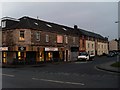
1
A82 west passing Arnold Clark motor dealers
Footbridge can be seen crossing road
Image: © John Firth
Taken: 12 May 2012
0.15 miles
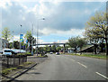
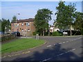
2
Old Mill Road
By the Duntocher Burn.
Image: © Stephen Sweeney
Taken: 5 Apr 2009
0.18 miles
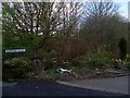
3
Corner of Roman Road and Milton Douglas Road
Roman Road in Duntocher is possibly the oldest road in Clydebank, and is believed to cross the oldest bridge in Scotland.
Image: © Stephen Sweeney
Taken: 24 Jul 2008
0.21 miles
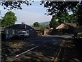
4
Mallard Road, Duntocher
Just off Milton Douglas Road.
Image: © Stephen Sweeney
Taken: 24 Jul 2008
0.24 miles
5
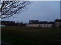
Football pitch in Duntocher
Viewed from Dumbarton Road.
Image: © Stephen Sweeney
Taken: 9 Apr 2008
0.24 miles
6
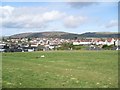
Northwest view from Kilbowie Hill
Across Parkhall to the Kilpatrick Hills. The Slacks is on the left, with Cochno Hill to the right.
Image: © Stephen Sweeney
Taken: 5 Apr 2009
0.24 miles