IMAGES TAKEN NEAR TO
Braemar Avenue, CLYDEBANK, G81 3RP
Introduction
This page details the photographs taken nearby to Braemar Avenue, G81 3RP by members of the Geograph project.
The Geograph project started in 2005 with the aim of publishing, organising and preserving representative images for every square kilometre of Great Britain, Ireland and the Isle of Man.

There are currently over 7.5m images from over14,400 individuals and you can help contribute to the project by visiting https://www.geograph.org.uk
Image Map
Images are licensed for reuse under creativecommons.org/licenses/by-sa/2.0
Notes
- Clicking on the map will re-center to the selected point.
- The higher the marker number, the further away the image location is from the centre of the postcode.
Image Listing (4 Images Found)
Images are licensed for reuse under creativecommons.org/licenses/by-sa/2.0
Image
Details
Distance
1
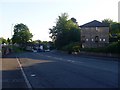
Duntocher Road, Parkhall
Heading towards the junction with Park Avenue.
Image: © Stephen Sweeney
Taken: 23 Jun 2009
0.19 miles
2
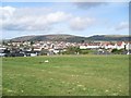
Northwest view from Kilbowie Hill
Across Parkhall to the Kilpatrick Hills. The Slacks is on the left, with Cochno Hill to the right.
Image: © Stephen Sweeney
Taken: 5 Apr 2009
0.24 miles
3
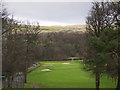
Dalmuir Golf Course
Clydebank's only public course.
Image: © Stephen Sweeney
Taken: 24 Jan 2007
0.25 miles
4
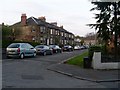
Methven Street, Parkhall
Opposite the Overtoun Road entrance to Dalmuir Park.
Image: © Stephen Sweeney
Taken: 20 Apr 2009
0.25 miles