IMAGES TAKEN NEAR TO
Duntocher Road, CLYDEBANK, G81 3LL
Introduction
This page details the photographs taken nearby to Duntocher Road, G81 3LL by members of the Geograph project.
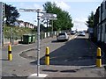
The Geograph project started in 2005 with the aim of publishing, organising and preserving representative images for every square kilometre of Great Britain, Ireland and the Isle of Man.

There are currently over 7.5m images from over14,400 individuals and you can help contribute to the project by visiting https://www.geograph.org.uk
Image Map
Images are licensed for reuse under creativecommons.org/licenses/by-sa/2.0
Notes
- Clicking on the map will re-center to the selected point.
- The higher the marker number, the further away the image location is from the centre of the postcode.
Image Listing (150 Images Found)
Images are licensed for reuse under creativecommons.org/licenses/by-sa/2.0
Image
Details
Distance
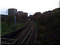
1
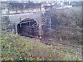
Duntocher Road railway tunnel
Over the railway lines just before Dalmuir station.
Image: © Stephen Sweeney
Taken: 30 Dec 2007
0.03 miles
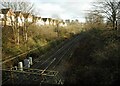
2
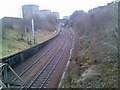
Railway lines leading to Dalmuir Station
The station platform can just be seen behind the arched tunnel.
Image: © Stephen Sweeney
Taken: 30 Dec 2007
0.04 miles
3
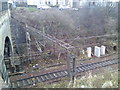
Railway lines and tunnel, Dalmuir
Seen from Duntocher Road.
Image: © Stephen Sweeney
Taken: 30 Dec 2007
0.04 miles
4
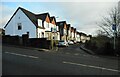
Houses on one-way street
The houses overlook the railway line and face south. The street name? South View.
Image: © Richard Sutcliffe
Taken: 21 Jan 2022
0.04 miles
5
Railway lines approach Dalmuir Station
From the west.
Image: © Stephen Sweeney
Taken: 9 Apr 2008
0.05 miles
6
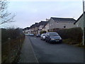
South View, Dalmuir
Small, quiet street by Dalmuir train station.
Image: © Stephen Sweeney
Taken: 30 Dec 2007
0.05 miles
7

Dalmuir, Erskine Bridge and Firth of Clyde from the air
I can think of no finer sight on the approaches to any airport that I have visited around the world than that of the Firth of Clyde and the distant Argyll hills. Low winter sun, frost and a hint of mist contribute to the ethereal atmosphere on this occasion.
Dalmuir with its towerblocks, bonded warehouses and Golden Jubilee National Hospital is in the foreground. The Forth & Clyde Canal can also be seen in the foreground, snaking its way to the western terminus at Bowling Basin which is on the right just beyond the Erskine Bridge. The town of Erskine is on the left bank, with the HPE campus visible amongst the trees just beyond the south end of the bridge.
The Lang Dyke https://www.geograph.org.uk/snippet/1919 of the navigable channel in the Clyde is prominent as it passes Dumbarton Rock, with the town of Dumbarton to its right. Port Glasgow and Greenock are visible in the left distance, with Ardmore peninsula on the right. The distant sea lochs from left to right are Holy Loch, Loch Long and Gareloch (or Gare Loch).
The magnificent array of the snow-capped south Argyll hills provides the backdrop.
Image: © Thomas Nugent
Taken: 11 Dec 2017
0.06 miles
8
Railway line looking towards Clydebank and Yoker
The houses on the left are on South View.
Image: © Richard Sutcliffe
Taken: 21 Jan 2022
0.06 miles
9
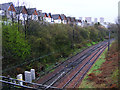
Railway line east of Dalmuir station
The line to Clydebank and Yoker, just before it passes under the Singer line. Viewed from Duntocher Road. The houses are on South View.
Image: © Thomas Nugent
Taken: 5 Apr 2011
0.07 miles
10
Directional signpost at Dalmuir Station
Between the two platforms of the Singer and Yoker lines.
Image: © Stephen Sweeney
Taken: 17 Aug 2008
0.07 miles