IMAGES TAKEN NEAR TO
Onslow Road, CLYDEBANK, G81 2PN
Introduction
This page details the photographs taken nearby to Onslow Road, G81 2PN by members of the Geograph project.
The Geograph project started in 2005 with the aim of publishing, organising and preserving representative images for every square kilometre of Great Britain, Ireland and the Isle of Man.

There are currently over 7.5m images from over14,400 individuals and you can help contribute to the project by visiting https://www.geograph.org.uk
Image Map
Images are licensed for reuse under creativecommons.org/licenses/by-sa/2.0
Notes
- Clicking on the map will re-center to the selected point.
- The higher the marker number, the further away the image location is from the centre of the postcode.
Image Listing (82 Images Found)
Images are licensed for reuse under creativecommons.org/licenses/by-sa/2.0
Image
Details
Distance
1
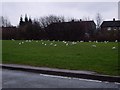
The Birds
For a second, I started to think Hitchcock had predicted the future...
Image: © Stephen Sweeney
Taken: 18 Jan 2008
0.03 miles
2
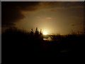
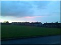
Sunrise over trees in Linnvale
Another view of the glorious sunrise from Image
Image: © Stephen Sweeney
Taken: 30 Jan 2008
0.03 miles
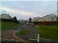
3
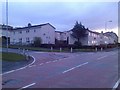
Drumry housing - Onslow Road and Wandilla Avenue
Image: © Stephen Sweeney
Taken: 8 Jan 2008
0.04 miles
5
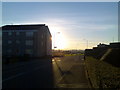
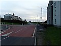
Flats on Onslow Road, Drumry
Almost obscured by the bright sunlight from behind them.
Image: © Stephen Sweeney
Taken: 19 Oct 2007
0.06 miles
6
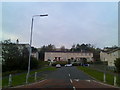
Drumry houses
Houses on Montrose Street, viewed from the bottom of Wandilla Avenue.
Image: © Stephen Sweeney
Taken: 24 Oct 2007
0.07 miles
7
Housing in Drumry
Looking along York Street.
Image: © Stephen Sweeney
Taken: 24 Oct 2007
0.07 miles
8
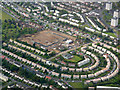
Drumry from the air
The streets in the semi-circle are Vanguard, Hood and Queen Mary, possibly named after Clydebank built ships. The brownfield site is the location of the former Braidfield High School.
Image: © Thomas Nugent
Taken: 6 May 2019
0.07 miles
9
Linnvale housing from Onslow Road
Looking across the railway to houses on Greenwood Quadrant.
Image: © Stephen Sweeney
Taken: 8 Jan 2008
0.08 miles
10
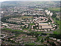
Drumry and Linnvale from the air
Suburban housing near Drumchapel. Looking northwest on the way to Glasgow Airport, less than a minute from landing. The five tower blocks on the right, by the A82 Great Western Road, are on Kirkoswald Drive; successively, from the nearest they are Peel, Gleniffer, Garscadden, Duncombe and Cleddans Views.
Image: © M J Richardson
Taken: 3 Oct 2015
0.08 miles