IMAGES TAKEN NEAR TO
Robert Burns Avenue, CLYDEBANK, G81 2ED
Introduction
This page details the photographs taken nearby to Robert Burns Avenue, G81 2ED by members of the Geograph project.
The Geograph project started in 2005 with the aim of publishing, organising and preserving representative images for every square kilometre of Great Britain, Ireland and the Isle of Man.

There are currently over 7.5m images from over14,400 individuals and you can help contribute to the project by visiting https://www.geograph.org.uk
Image Map
Images are licensed for reuse under creativecommons.org/licenses/by-sa/2.0
Notes
- Clicking on the map will re-center to the selected point.
- The higher the marker number, the further away the image location is from the centre of the postcode.
Image Listing (94 Images Found)
Images are licensed for reuse under creativecommons.org/licenses/by-sa/2.0
Image
Details
Distance
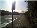
1
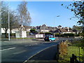
Drumry housing
From Drumry Road. The housing is on Clarence Street and Robert Burns Avenue.
Image: © Stephen Sweeney
Taken: 8 Nov 2007
0.03 miles
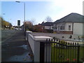
2
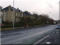
Houses on Drumry Road
One of the more affluent areas of Clydebank.
Image: © Stephen Sweeney
Taken: 12 Mar 2007
0.05 miles
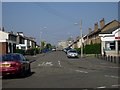
6
Drumry Road bungalows
Drumry Road has some of the best housing in the Clydebank area.
Image: © Stephen Sweeney
Taken: 8 Nov 2007
0.10 miles
8
Riddell Street, Drumry
Looking to the partially-demolished Clydebank College.
Image: © Stephen Sweeney
Taken: 8 May 2008
0.12 miles
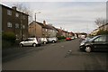
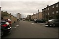
9
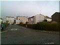
Typical Drumry housing
These houses, on Robert Burns Avenue and Jean Armour Drive, are more typical of the housing in this residential area. Viewed from along Alloway Drive.
Image: © Stephen Sweeney
Taken: 8 Nov 2007
0.13 miles
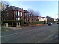
10
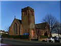
Kilbowie St. Andrew's Parish Church, Clydebank
On the corner of Kilbowie Road and Drumry Road.
Image: © Stephen Sweeney
Taken: 6 Feb 2008
0.13 miles