IMAGES TAKEN NEAR TO
Gilmour Street, CLYDEBANK, G81 2BW
Introduction
This page details the photographs taken nearby to Gilmour Street, G81 2BW by members of the Geograph project.
The Geograph project started in 2005 with the aim of publishing, organising and preserving representative images for every square kilometre of Great Britain, Ireland and the Isle of Man.

There are currently over 7.5m images from over14,400 individuals and you can help contribute to the project by visiting https://www.geograph.org.uk
Image Map (Loading...)


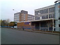
Getting Data...Please wait
Leaflet Map data © OpenStreetMap
Images are licensed for reuse under creativecommons.org/licenses/by-sa/2.0
Notes
- Clicking on the map will re-center to the selected point.
- The higher the marker number, the further away the image location is from the centre of the postcode.
Image Listing (38 Images Found)
Images are licensed for reuse under creativecommons.org/licenses/by-sa/2.0
Image
Details
Distance
1
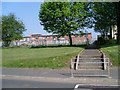
St Columba's High School
The present high school, from East Thomson Street.
Image: © Stephen Sweeney
Taken: 8 May 2008
0.02 miles
2
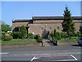
St Eunan's Church, Drumry
Catholic church on East Thomson Street.
Image: © Stephen Sweeney
Taken: 8 May 2008
0.05 miles
3
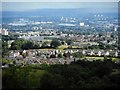
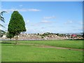
The view from Cochnohill (2)
A zoomed view looking south-southeast from Cochnohill. The flat-roofed building just to left of centre is St Peter the Apostle High School.
Image: © Richard Sutcliffe
Taken: 10 Jul 2020
0.07 miles
4
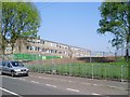
Construction site of new Catholic high school in Clydebank
On the present site of St Columba's High School, a new school, St Peter the Apostle, is being constructed, which will combine students of St Columba's and St Andrew's High Schools. Both of these schools will then be closed down.
Image: © Stephen Sweeney
Taken: 8 May 2008
0.12 miles
5
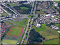
Kilbowie Road from the air
The A82 'Boulevard' is the main road, leading eventually to Inverness via Dumbarton, Loch Lomond and Fort William. Clydebank fire station is to the right of the roundabout.
Image: © Thomas Nugent
Taken: 17 Sep 2017
0.14 miles
7
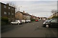
Across the grass to East Thomson Street
From Kilbowie Road, outside the old Clydebank College.
Image: © Stephen Sweeney
Taken: 12 Apr 2008
0.17 miles
8
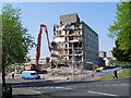
Ongoing demolition of Clydebank College
After the completion of the new Clydebank College, the old one is being cleared away to make room for more flats.
Image: © Stephen Sweeney
Taken: 8 May 2008
0.18 miles
9
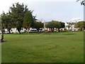
Clydebank College old buildings
At the top of Kilbowie Hill.
Image: © Stephen Sweeney
Taken: 4 Nov 2007
0.19 miles
10
Rubble, formerly Clydebank College
From Kilbowie Road, looking into the college demolition site.
Image: © Stephen Sweeney
Taken: 19 Jul 2008
0.19 miles