IMAGES TAKEN NEAR TO
Bon Accord Square, CLYDEBANK, G81 1YW
Introduction
This page details the photographs taken nearby to Bon Accord Square, G81 1YW by members of the Geograph project.
The Geograph project started in 2005 with the aim of publishing, organising and preserving representative images for every square kilometre of Great Britain, Ireland and the Isle of Man.

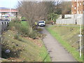
There are currently over 7.5m images from over14,400 individuals and you can help contribute to the project by visiting https://www.geograph.org.uk
Image Map
Images are licensed for reuse under creativecommons.org/licenses/by-sa/2.0
Notes
- Clicking on the map will re-center to the selected point.
- The higher the marker number, the further away the image location is from the centre of the postcode.
Image Listing (177 Images Found)
Images are licensed for reuse under creativecommons.org/licenses/by-sa/2.0
Image
Details
Distance
1
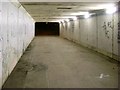
Tunnel under Glasgow Road
Takes the Glasgow-Loch Lomond Cycleway under the busiest road in the town. Former route of the Glasgow, Yoker and Clydebank Railway also ran this way.
Image: © Stephen Sweeney
Taken: 22 Nov 2008
0.01 miles
2
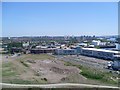
View across Glasgow from the Titan Crane
Looking east, across Yoker, Knightswood and Scotstoun, towards Glasgow University and the Clyde Auditorium, which can just about be seen in the distance.
Image: © Stephen Sweeney
Taken: 31 May 2009
0.01 miles
3
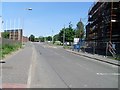
Cart Street
Looking to the Argyll Road railway bridge in the distance. New flats being built on the right of the image.
Image: © Stephen Sweeney
Taken: 31 May 2009
0.02 miles
4
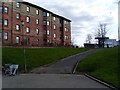
Flats on Bon Accord Square
In Clydebank.
Image: © Stephen Sweeney
Taken: 6 Apr 2008
0.02 miles
5
Cycle path and walkway
The view of the cycle path and walkway as seen from Glasgow Road.
The cycle path follows the route of the former London Midland and Scottish railway line from Partick to Dumbarton. This line followed the northern bank of the Clyde and from Clydebank to Dumbarton criss-crossed the London North Eastern line (the present Partick to Dumbarton via Yoker line). The railway bridge which carries the present line over the cycle path and Argyll Road can be seen on the left.
Image: © Sandy Gemmill
Taken: 12 Mar 2009
0.03 miles
6

Cart Street
This street is a reminder of a former, long-lost canal https://maps.nls.uk/geo/explore/#zoom=15&lat=55.89827&lon=-4.40014&layers=5&b=1. The road follows part of the original line of the Forth and Cart Canal. The canal was built to link the River Cart, just across the River Clyde with the Forth and Clyde Canal and to give access for goods from Paisley via the canals to Edinburgh in the east. Opened in 1840 the canal ran for half a mile, joining the Forth and Clyde Canal at Whitecrook. It was never very successful and closed in 1893. See https://canmore.org.uk/site/368255/forth-and-cart-canal for more information.
Image: © Richard Sutcliffe
Taken: 21 Jan 2022
0.03 miles
7
Sign for the Redevelopment of Clydebank
With info on the works to be carried out.
Image: © Stephen Sweeney
Taken: 17 Jun 2007
0.03 miles
8
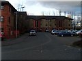
Bon Accord Square, Clydebank
Relatively new flats in the Clydebank waterfront area.
Image: © Stephen Sweeney
Taken: 17 Mar 2008
0.03 miles
9
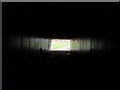
Light at the end of the tunnel
This tunnel takes the Glasgow-Loch Lomond Cycleway under the busy Glasgow Road.
Image: © Stephen Sweeney
Taken: 6 Apr 2008
0.03 miles
10
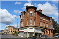
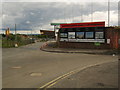
Corner of Glasgow Road & Whitecrook Street, Clydebank
Image: © Leslie Barrie
Taken: 23 Aug 2014
0.03 miles