IMAGES TAKEN NEAR TO
Glasgow Road, CLYDEBANK, G81 1QQ
Introduction
This page details the photographs taken nearby to Glasgow Road, G81 1QQ by members of the Geograph project.
The Geograph project started in 2005 with the aim of publishing, organising and preserving representative images for every square kilometre of Great Britain, Ireland and the Isle of Man.

There are currently over 7.5m images from over14,400 individuals and you can help contribute to the project by visiting https://www.geograph.org.uk
Image Map
Images are licensed for reuse under creativecommons.org/licenses/by-sa/2.0
Notes
- Clicking on the map will re-center to the selected point.
- The higher the marker number, the further away the image location is from the centre of the postcode.
Image Listing (167 Images Found)
Images are licensed for reuse under creativecommons.org/licenses/by-sa/2.0
Image
Details
Distance
1
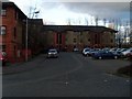
Bon Accord Square, Clydebank
Relatively new flats in the Clydebank waterfront area.
Image: © Stephen Sweeney
Taken: 17 Mar 2008
0.01 miles
2
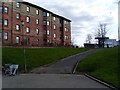
Flats on Bon Accord Square
In Clydebank.
Image: © Stephen Sweeney
Taken: 6 Apr 2008
0.03 miles
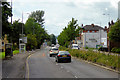
5
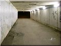
Tunnel under Glasgow Road
Takes the Glasgow-Loch Lomond Cycleway under the busiest road in the town. Former route of the Glasgow, Yoker and Clydebank Railway also ran this way.
Image: © Stephen Sweeney
Taken: 22 Nov 2008
0.04 miles
6
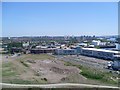
View across Glasgow from the Titan Crane
Looking east, across Yoker, Knightswood and Scotstoun, towards Glasgow University and the Clyde Auditorium, which can just about be seen in the distance.
Image: © Stephen Sweeney
Taken: 31 May 2009
0.04 miles
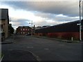
7
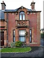
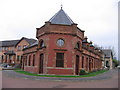
Former station building
The former Clydebank Riverside Station, which closed in 1965. Now converted to housing, the Category B listed building http://portal.historicenvironment.scot/designation/LB22988 dates from about 1896, when it was built for the Lanarkshire and Dumbartonshire Railway (a subsidiary of the Caledonian Railway). The CR carved in the balcony stands for Caledonian Railway.
Image: © Richard Sutcliffe
Taken: 21 Jan 2022
0.05 miles
8
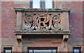
Carved stonework
The CR carved in the balcony stands for Caledonian Railway. It is part of the former Clydebank Riverside Station, which closed in 1965. Now converted to housing, the Category B listed building http://portal.historicenvironment.scot/designation/LB22988 dates from about 1896, when it was built for the Lanarkshire and Dumbartonshire Railway (a subsidiary of the Caledonian Railway).
See Image for a wider view.
Image: © Richard Sutcliffe
Taken: 21 Jan 2022
0.05 miles
9
Clydebank Riverside railway station
During the first half of the twentieth century Clydebank was well supplied with railway stations, three bearing the town's name and two others at Kilbowie being within 1000 yards of the town centre. The one shown here was opened in October 1896 by the Caledoniain Railway and further distinguished from the other two Clydebank (North British Railway) stations the following year by the addition of the suffix "Riverside". It closed in October 1964 but the building was not demolished and has been incorporated with sensitivity into a housing scheme called Cunard Court. The platform side was to the left, where the track was curving sharply round to the north to pass under the NBR line before climbing and passing over and to the south of the NBR again a mile or so to the west. The frontage to the right, alongside the road, incorporated flats for the station staff and, distinguished by having balcony with a large "CR" monogram, a house at the end for the station master.
Image: © A-M-Jervis
Taken: 15 Dec 2007
0.05 miles
10
New housing development in Clydebank
Queens Gate housing development is that rarity - rentable flats being constructed.
Image: © Stephen Sweeney
Taken: 6 Apr 2008
0.05 miles