IMAGES TAKEN NEAR TO
Cart Street, CLYDEBANK, G81 1QJ
Introduction
This page details the photographs taken nearby to Cart Street, G81 1QJ by members of the Geograph project.
The Geograph project started in 2005 with the aim of publishing, organising and preserving representative images for every square kilometre of Great Britain, Ireland and the Isle of Man.

There are currently over 7.5m images from over14,400 individuals and you can help contribute to the project by visiting https://www.geograph.org.uk
Image Map
Images are licensed for reuse under creativecommons.org/licenses/by-sa/2.0
Notes
- Clicking on the map will re-center to the selected point.
- The higher the marker number, the further away the image location is from the centre of the postcode.
Image Listing (205 Images Found)
Images are licensed for reuse under creativecommons.org/licenses/by-sa/2.0
Image
Details
Distance
1
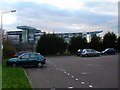
Clydebank College and Titan Crane
From the car park at Cunard Street.
Image: © Stephen Sweeney
Taken: 17 Mar 2008
0.01 miles
2
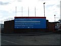
Latest sign at Queens Quay
This sign changes as new developments occur.
Image: © Stephen Sweeney
Taken: 6 Apr 2008
0.01 miles
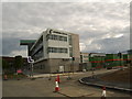
3
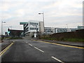
Clydebank College
The local campus for the West College, Scotland, set on what once were shipyards.
Image: © James Denham
Taken: 24 Nov 2013
0.02 miles
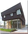
4
New housing development in Clydebank
Queens Gate housing development is that rarity - rentable flats being constructed.
Image: © Stephen Sweeney
Taken: 6 Apr 2008
0.02 miles
5
Clydebank Riverside railway station
During the first half of the twentieth century Clydebank was well supplied with railway stations, three bearing the town's name and two others at Kilbowie being within 1000 yards of the town centre. The one shown here was opened in October 1896 by the Caledoniain Railway and further distinguished from the other two Clydebank (North British Railway) stations the following year by the addition of the suffix "Riverside". It closed in October 1964 but the building was not demolished and has been incorporated with sensitivity into a housing scheme called Cunard Court. The platform side was to the left, where the track was curving sharply round to the north to pass under the NBR line before climbing and passing over and to the south of the NBR again a mile or so to the west. The frontage to the right, alongside the road, incorporated flats for the station staff and, distinguished by having balcony with a large "CR" monogram, a house at the end for the station master.
Image: © A-M-Jervis
Taken: 15 Dec 2007
0.03 miles
6

Titan Crane appears behind wall
One of the last remaining walls of John Brown's shipyard.
Image: © Stephen Sweeney
Taken: 6 Apr 2008
0.03 miles
7
A building at Clydebank College
Clydebank College was still under construction when this picture was taken.
The roof does feature the acute angles shown here; they are not simply photographic distortion.
Image: © Lairich Rig
Taken: 17 Aug 2007
0.03 miles
8
New Clydebank College nearing completion
Due to open in less than two months.
Image: © Stephen Sweeney
Taken: 17 Jun 2007
0.03 miles
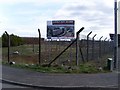
9
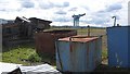
Land awaiting development, Clydebank
Scrap metal on a shipyard site. The Titan Crane is in the background with its added liftshaft.
Image: © Richard Webb
Taken: 9 May 2012
0.04 miles
10
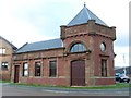
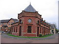
Booking office of Clydebank East Riverside Station
Clydebank East Riverside Station was situated on the Glasgow, Yoker and Clydebank Railway, and was a short walk from John Brown's shipyard. The ticket office - now converted into a house - is all that remains of the station.
Image: © Stephen Sweeney
Taken: 17 Mar 2008
0.04 miles