IMAGES TAKEN NEAR TO
McGregor Street, CLYDEBANK, G81 1HQ
Introduction
This page details the photographs taken nearby to McGregor Street, G81 1HQ by members of the Geograph project.
The Geograph project started in 2005 with the aim of publishing, organising and preserving representative images for every square kilometre of Great Britain, Ireland and the Isle of Man.

There are currently over 7.5m images from over14,400 individuals and you can help contribute to the project by visiting https://www.geograph.org.uk
Image Map (Loading...)


Getting Data...Please wait
Leaflet Map data © OpenStreetMap
Images are licensed for reuse under creativecommons.org/licenses/by-sa/2.0
Notes
- Clicking on the map will re-center to the selected point.
- The higher the marker number, the further away the image location is from the centre of the postcode.
Image Listing (59 Images Found)
Images are licensed for reuse under creativecommons.org/licenses/by-sa/2.0
Image
Details
Distance
1
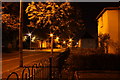
Starlights in the street
A night shot from East Barns Street towards Barns Street.
Image: © Robert McCumesty
Taken: 7 Oct 2009
0.05 miles
2
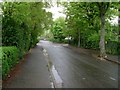
White Street, Whitecrook
Attractive little avenue in Clydebank.
Image: © Stephen Sweeney
Taken: 30 Apr 2009
0.09 miles
3
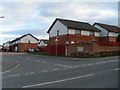
Jane Rae Gardens, Clydebank
Housing estate built in 1997 and named after political activist Jane Rae, member of the Independent Labour Party from 1913 and councillor for Clydebank from 1922 to 1928. Jane Rae was sacked from the Singer factory in 1911 for her involvement in a strike, and chaired a meeting for suffragette Emily Pankhurst at Clydebank Town Hall.
Image: © Stephen Sweeney
Taken: 17 Mar 2008
0.09 miles
4
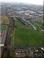
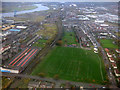
Whitecrook Park from the air
Alongside the Argyl Line railway between Drumry and Singer.
Image: © Thomas Nugent
Taken: 24 Feb 2017
0.12 miles
5
Whitecrook Park from the air
On final approach to Glasgow Airport from the north east.
Image: © Thomas Nugent
Taken: 3 Nov 2017
0.13 miles
6
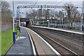
An easterly view along the platform of Yoker railway station in Glasgow
The platforms at Yoker railway station in Glasgow. Yoker is in the very west of Glasgow at the border with Clydebank. The next westbound station on the line is Clydebank whilst the next eastbound station in Garscadden.
Image: © Garry Cornes
Taken: 3 Jan 2016
0.13 miles
7
East Barns Street, Whitecrook
Junction with North Elgin Street, which leads to the Forth and Clyde Canal.
Image: © Barbara Carr
Taken: 18 Apr 2013
0.13 miles
8
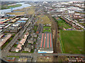
Clydebank from the air
The large building in the foreground is a go-karting and soft play centre.
Image: © Thomas Nugent
Taken: 7 Apr 2016
0.15 miles
9
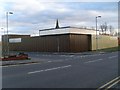
JKS Workshops, Whitecrook
New business premises in Clydebank.
Image: © Stephen Sweeney
Taken: 17 Mar 2008
0.15 miles
10
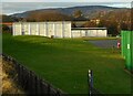
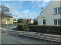
Unidentified building
In the grounds of Our Holy Redeemer's Primary, Clydebank. Possibly a gymnasium?
Image: © Richard Sutcliffe
Taken: 21 Jan 2022
0.15 miles