IMAGES TAKEN NEAR TO
Rosebery Street, G81 1ED
Introduction
This page details the photographs taken nearby to Rosebery Street, G81 1ED by members of the Geograph project.
The Geograph project started in 2005 with the aim of publishing, organising and preserving representative images for every square kilometre of Great Britain, Ireland and the Isle of Man.

There are currently over 7.5m images from over14,400 individuals and you can help contribute to the project by visiting https://www.geograph.org.uk
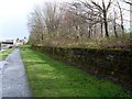
Image Map
Images are licensed for reuse under creativecommons.org/licenses/by-sa/2.0
Notes
- Clicking on the map will re-center to the selected point.
- The higher the marker number, the further away the image location is from the centre of the postcode.
Image Listing (286 Images Found)
Images are licensed for reuse under creativecommons.org/licenses/by-sa/2.0
Image
Details
Distance
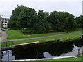
1
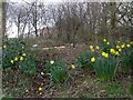
Woodland beside the Forth and Clyde Canal
On the south bank, near the council offices.
Image: © Stephen Sweeney
Taken: 24 Mar 2008
0.00 miles
2
Woodland by canal in Clydebank
Between the canal and the council offices. This is the site of the former Kilbowie train station, part of the Glasgow, Yoker and Clydebank railway line which closed in 1964.
Image: © Stephen Sweeney
Taken: 24 Mar 2008
0.01 miles
3
Kilbowie railway station (site), Dunbartonshire
Opened in 1896 as "Kilbowie Road" by the Lanarkshire and Dumbartonshire Railway, part of the Caledonian Railway, on the line from Partick to Dumbarton. The name was shortened to "Kilbowie" in 1908. The station closed in 1964.
View west towards Dalmuir Riverside and Dumbarton. All trace of the railway and station, which would have been on a viaduct overhead at this point, has been swept away.
Image: © Nigel Thompson
Taken: 21 Feb 2019
0.01 miles
4
Woodland alongside the Forth and Clyde Canal in Clydebank
Looking east along the canal bank towards Clyde Shopping Centre.
Image: © Stephen Sweeney
Taken: 30 Mar 2008
0.02 miles
5
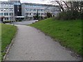
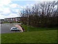
Pathway to West Dunbartonshire council offices
From the canal.
Image: © Stephen Sweeney
Taken: 24 Mar 2008
0.02 miles
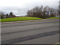
6
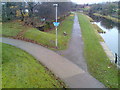
Glasgow-Loch Lomond Cycleway at Clydebank
Following the canal bank right along to Bowling Harbour.
Image: © Stephen Sweeney
Taken: 2 Dec 2007
0.02 miles
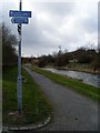
7
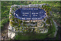
Distance Marker, Forth and Clyde Canal
Set on the south side of the canal close to the Kilbowie Road bridge.
Image: © Stephen McKay
Taken: 19 Mar 2008
0.02 miles
8
Forth and Clyde Canal from Kilbowie Road
Image: © Stephen Sweeney
Taken: 14 Aug 2008
0.03 miles
9
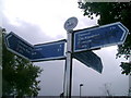
Forth and Clyde Canal signage
This sadly abused signage indicates distances to destinations on the Forth and Clyde Canal as well as local facilities in Clydebank.
Image: © Mark Nightingale
Taken: 30 Sep 2009
0.03 miles
10
Glasgow-Loch Lomond Cycleway follows the Forth and Clyde Canal
With signposts handily keeping cyclists and pedestrians on the right track.
Image: © Stephen Sweeney
Taken: 24 Mar 2008
0.03 miles