IMAGES TAKEN NEAR TO
John Knox Street, CLYDEBANK, G81 1BQ
Introduction
This page details the photographs taken nearby to John Knox Street, G81 1BQ by members of the Geograph project.
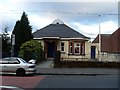
The Geograph project started in 2005 with the aim of publishing, organising and preserving representative images for every square kilometre of Great Britain, Ireland and the Isle of Man.

There are currently over 7.5m images from over14,400 individuals and you can help contribute to the project by visiting https://www.geograph.org.uk
Image Map
Images are licensed for reuse under creativecommons.org/licenses/by-sa/2.0
Notes
- Clicking on the map will re-center to the selected point.
- The higher the marker number, the further away the image location is from the centre of the postcode.
Image Listing (120 Images Found)
Images are licensed for reuse under creativecommons.org/licenses/by-sa/2.0
Image
Details
Distance
1
St Andrew's High School
Catholic school on North Douglas Street, Clydebank.
Image: © Stephen Sweeney
Taken: 17 Mar 2008
0.01 miles
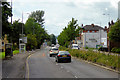
2
Flats on Glasgow Road
In Whitecrook.
Image: © Stephen Sweeney
Taken: 17 Mar 2008
0.04 miles
3
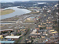
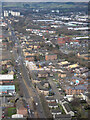
Clydebank from the air
Lots of brownfield sites in this view over Yoker towards Clydebank Town Hall and the site of John Brown's shipyard.
Image: © Thomas Nugent
Taken: 24 Jan 2020
0.05 miles
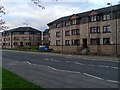
4
Clydebank Bowling Club
On John Knox Street.
Image: © Stephen Sweeney
Taken: 17 Mar 2008
0.07 miles
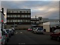
5
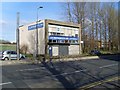
JC Roxburgh Insurance, Clydebank
On Glasgow Road.
Image: © Stephen Sweeney
Taken: 6 Apr 2008
0.08 miles
6
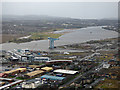
Flooded River Clyde from the air
The water is higher than usual due to Storm Erik which also made for a bumpy approach to Glasgow over Clydebank.
Image: © Thomas Nugent
Taken: 8 Feb 2019
0.08 miles
7
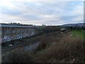
Railway lines beside John Brown's football pitches
With a westbound train heading for Clydebank station.
Image: © Stephen Sweeney
Taken: 17 Mar 2008
0.09 miles
8
The A814 Dumbarton Road from the air
Running through Clydebank from Yoker in the foreground to Dalmuir in the distance.
Image: © Thomas Nugent
Taken: 24 Jan 2020
0.09 miles
9
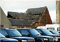
Church ruins
Part of the former St Columba's Episcopal Church, seen from Clyde Street. The church has been unused since at least 2004 and has been subject to vandalism over the years. Parts of the roof collapsed sometime between 2017 and 2019 (based on Street View images) and it continues to deteriorate. The building is on the Buildings at Risk Register https://www.buildingsatrisk.org.uk/details/904186.
Image: © Richard Sutcliffe
Taken: 21 Jan 2022
0.10 miles