IMAGES TAKEN NEAR TO
Neukfoot Lane, GLASGOW, G78 4DH
Introduction
This page details the photographs taken nearby to Neukfoot Lane, G78 4DH by members of the Geograph project.
The Geograph project started in 2005 with the aim of publishing, organising and preserving representative images for every square kilometre of Great Britain, Ireland and the Isle of Man.

There are currently over 7.5m images from over14,400 individuals and you can help contribute to the project by visiting https://www.geograph.org.uk
Image Map
Images are licensed for reuse under creativecommons.org/licenses/by-sa/2.0
Notes
- Clicking on the map will re-center to the selected point.
- The higher the marker number, the further away the image location is from the centre of the postcode.
Image Listing (20 Images Found)
Images are licensed for reuse under creativecommons.org/licenses/by-sa/2.0
Image
Details
Distance
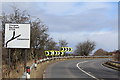
1
Road junction A736 Lochlibo Road & Neilston Road, Uplawmoor
Image: © Leslie Barrie
Taken: 23 Mar 2015
0.03 miles
2
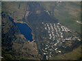
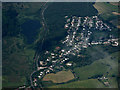
Uplawmoor from the air
Off the A736 Lochlibo Road. Loch Libo can be seen on the left, with the Glasgow to Kilmarnock railway line running alongside.
Image: © Thomas Nugent
Taken: 27 Mar 2022
0.04 miles
4
Uplawmoor from the air
Loch Libo, The Glasgow to Kilmarnock railway and the A736 Lochlibo Road are on the left.
Image: © Thomas Nugent
Taken: 15 Jul 2019
0.08 miles
5
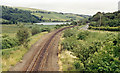
Site of Caldwell - later Uplawmoor, station
This is the former Glasgow, Barrhead & Kilmarnock (later Glasgow & South-Western) line from Glasgow St Enoch, later from Glasgow Central - and by 1986 single-track, to Kilmarnock and Carlisle. Until 2/4/62 Caldwell was named 'Uplawmoor'; it was closed on 7/11/66 - after having been portrayed on TV as 'Tannochbrae' in 'Dr Finlay's Casebook'. The water ahead is Loch Libo.
Image: © Ben Brooksbank
Taken: 6 Jul 1986
0.08 miles
6
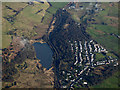
Uplawmoor from the air
Loch Libo is also prominent, separated from the village by the Glasgow to Kilmarnock railway line and the A736 Lochlibo Road. The line of the disused Lanarkshire & Ayrshire railway can be seen to the right of the village https://www.railscot.co.uk/companies/L/Lanarkshire_and_Ayrshire_Railway/ .
Image: © Thomas Nugent
Taken: 11 Feb 2019
0.12 miles
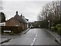
8
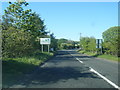
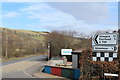
A736 at East Renfrewshire boundary at Bow Bridge
Image: © Colin Pyle
Taken: 10 Jun 2015
0.15 miles
9
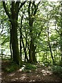
A row of beeches
Trees in Uplawmoor glen.
Image: © James Allan
Taken: 29 Jul 2009
0.16 miles