IMAGES TAKEN NEAR TO
Uplawmoor, GLASGOW, G78 4BW
Introduction
This page details the photographs taken nearby to G78 4BW by members of the Geograph project.
The Geograph project started in 2005 with the aim of publishing, organising and preserving representative images for every square kilometre of Great Britain, Ireland and the Isle of Man.

There are currently over 7.5m images from over14,400 individuals and you can help contribute to the project by visiting https://www.geograph.org.uk
Image Map
Images are licensed for reuse under creativecommons.org/licenses/by-sa/2.0
Notes
- Clicking on the map will re-center to the selected point.
- The higher the marker number, the further away the image location is from the centre of the postcode.
Image Listing (10 Images Found)
Images are licensed for reuse under creativecommons.org/licenses/by-sa/2.0
Image
Details
Distance
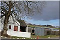
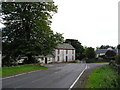
3
Derelict building at crossroads
crossing the Gleniffer Road
Image: © G McK
Taken: 31 Jul 2007
0.02 miles
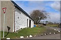
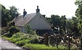
5
Crossroads
Crossroads on the B775 & B776.
Image: © Chris Court
Taken: 12 Sep 2005
0.05 miles
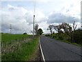
8
Hillside grazing and pylon near Braco
Off Gleniffer Road.
Image: © JThomas
Taken: 23 May 2021
0.16 miles
9
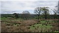
Rashy ground, Caldwell
Poorly drained soils with a grown out woodland.
Image: © Richard Webb
Taken: 21 May 2013
0.17 miles
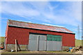
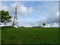
10
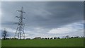
Power line, Braco
Braco, Renfrewshire: a bend in a power line that runs from Hunterston power station to Neilston substation on Gleniffer Braes.
Image: © Richard Webb
Taken: 21 May 2013
0.18 miles