IMAGES TAKEN NEAR TO
Uplawmoor, GLASGOW, G78 4BQ
Introduction
This page details the photographs taken nearby to G78 4BQ by members of the Geograph project.
The Geograph project started in 2005 with the aim of publishing, organising and preserving representative images for every square kilometre of Great Britain, Ireland and the Isle of Man.

There are currently over 7.5m images from over14,400 individuals and you can help contribute to the project by visiting https://www.geograph.org.uk
Image Map
Images are licensed for reuse under creativecommons.org/licenses/by-sa/2.0
Notes
- Clicking on the map will re-center to the selected point.
- The higher the marker number, the further away the image location is from the centre of the postcode.
Image Listing (4 Images Found)
Images are licensed for reuse under creativecommons.org/licenses/by-sa/2.0
Image
Details
Distance
1
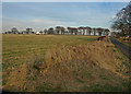
View across field to Whitehouse
Aptly named cottage.
Image: © wfmillar
Taken: 19 Feb 2008
0.17 miles
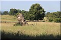
2

Minor road
Looking towards Greenend.
Image: © Richard Sutcliffe
Taken: 7 Jul 2023
0.23 miles
4
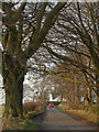
Tree lined road
Very low branch crosses the road leading past Whitehouse.
Image: © wfmillar
Taken: 19 Feb 2008
0.25 miles