IMAGES TAKEN NEAR TO
Duncarnock Avenue, GLASGOW, G78 3JW
Introduction
This page details the photographs taken nearby to Duncarnock Avenue, G78 3JW by members of the Geograph project.
The Geograph project started in 2005 with the aim of publishing, organising and preserving representative images for every square kilometre of Great Britain, Ireland and the Isle of Man.

There are currently over 7.5m images from over14,400 individuals and you can help contribute to the project by visiting https://www.geograph.org.uk
Image Map
Images are licensed for reuse under creativecommons.org/licenses/by-sa/2.0
Notes
- Clicking on the map will re-center to the selected point.
- The higher the marker number, the further away the image location is from the centre of the postcode.
Image Listing (40 Images Found)
Images are licensed for reuse under creativecommons.org/licenses/by-sa/2.0
Image
Details
Distance
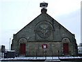
4
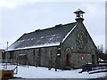
Neilston Parish Church Halls
On Kingston Road.
Image: © Thomas Nugent
Taken: 30 Dec 2009
0.19 miles
5
Neilston Parish Church Halls
On Kingston Road. See also Image
Image: © Thomas Nugent
Taken: 30 Dec 2009
0.19 miles
6
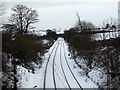
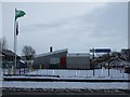
Railway at Neilston
Looking back towards Glasgow from the road bridge at Neilston station.
Image: © Thomas Nugent
Taken: 30 Dec 2009
0.19 miles
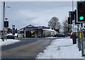
7
Kingston Road
Looking from High Street towards the railway station.
Image: © Thomas Nugent
Taken: 30 Dec 2009
0.20 miles
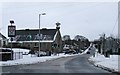
8
Kirkstyle Garage
On High Street, Neilston.
Image: © Thomas Nugent
Taken: 30 Dec 2009
0.20 miles
10
Madras Family Centre
A nursery school on Kingston Road. More information from this http://www.ea.e-renfrew.sch.uk/madras/
Image: © Thomas Nugent
Taken: 30 Dec 2009
0.21 miles