IMAGES TAKEN NEAR TO
Double Hedges Road, GLASGOW, G78 3JH
Introduction
This page details the photographs taken nearby to Double Hedges Road, G78 3JH by members of the Geograph project.
The Geograph project started in 2005 with the aim of publishing, organising and preserving representative images for every square kilometre of Great Britain, Ireland and the Isle of Man.

There are currently over 7.5m images from over14,400 individuals and you can help contribute to the project by visiting https://www.geograph.org.uk
Image Map
Images are licensed for reuse under creativecommons.org/licenses/by-sa/2.0
Notes
- Clicking on the map will re-center to the selected point.
- The higher the marker number, the further away the image location is from the centre of the postcode.
Image Listing (43 Images Found)
Images are licensed for reuse under creativecommons.org/licenses/by-sa/2.0
Image
Details
Distance
2
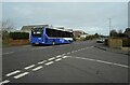
Bus for Paisley
A McGill's bus picking up passengers on Kingston Road.
Image: © Richard Sutcliffe
Taken: 23 Feb 2023
0.06 miles
3

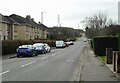
Craig Road
Residential street in Neilston.
Image: © Richard Sutcliffe
Taken: 23 Feb 2023
0.09 miles
4
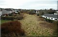
The line of the old railway
Looking from Double Hedges Road southwest along the route of the railway to Ardrossan. The former Lanarkshire and Ayrshire Railway closed in 1962.
Image: © Richard Sutcliffe
Taken: 23 Feb 2023
0.12 miles
5
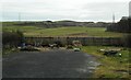
Gap site
Between houses on Craig Road. It may originally have been left to give access to the field beyond the fence.
Image: © Richard Sutcliffe
Taken: 23 Feb 2023
0.13 miles
6

The end of the line
This is the very end of the Glasgow to Neilston railway line. Originally the line continued past Neilston to Ardrossan, but the line beyond Neilston closed in 1962. This headshunt just southwest of the station allows trains from Glasgow to change tracks before travelling back there.
Image: © Richard Sutcliffe
Taken: 23 Feb 2023
0.14 miles
7
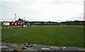
Brig O'Lea Park
Neilston Football Club's home ground.
Image: © Richard Sutcliffe
Taken: 23 Feb 2023
0.15 miles
8
Across playing fields in Neilston
Looking from Kingston Road across the football pitches towards the train depot just south of the station.
Image: © Stephen Sweeney
Taken: 6 Jan 2010
0.16 miles
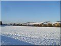
9
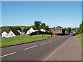
South edge of Neilston
We look north down Kingston Road, the road that heads south to Dunlop and Stewarton, at Neilston's southern edge.
Image: © Alec MacKinnon
Taken: 10 Jul 2022
0.16 miles
10
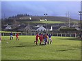
Brig o'Lea Stadium, Neilston. Football ground
Brig o'Lea Stadium. Home of Neilston Juniors FC. Looking south.
Image: © paul c
Taken: 23 Jan 2004
0.18 miles