IMAGES TAKEN NEAR TO
Lea Avenue, GLASGOW, G78 3EQ
Introduction
This page details the photographs taken nearby to Lea Avenue, G78 3EQ by members of the Geograph project.
The Geograph project started in 2005 with the aim of publishing, organising and preserving representative images for every square kilometre of Great Britain, Ireland and the Isle of Man.

There are currently over 7.5m images from over14,400 individuals and you can help contribute to the project by visiting https://www.geograph.org.uk
Image Map
Images are licensed for reuse under creativecommons.org/licenses/by-sa/2.0
Notes
- Clicking on the map will re-center to the selected point.
- The higher the marker number, the further away the image location is from the centre of the postcode.
Image Listing (100 Images Found)
Images are licensed for reuse under creativecommons.org/licenses/by-sa/2.0
Image
Details
Distance
2
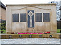
War Memorial, Neilston
Just off Main Street.
Image: © Richard Sutcliffe
Taken: 13 Mar 2017
0.11 miles
3
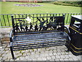
Second World War memorial bench, Neilston
Close to the War Memorial on Main Street.
Image: © Richard Sutcliffe
Taken: 13 Mar 2017
0.11 miles

6

Old building near Neilston station
Appears to be a former railway shed of some kind.
Image: © Thomas Nugent
Taken: 30 Dec 2009
0.13 miles
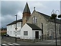
7

St Thomas' Catholic Church, Neilston
On Main Street, Neilston.
Image: © Richard Sutcliffe
Taken: 13 Mar 2017
0.13 miles
8
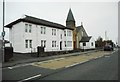
St Thomas' Catholic Church, Neilston
On Main Street, Neilston.
Image: © Richard Sutcliffe
Taken: 13 Mar 2017
0.13 miles
9
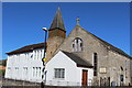
St Thomas' Catholic Church, Main Street, Neilston
Image: © Leslie Barrie
Taken: 9 Jul 2014
0.13 miles
10
St Thomas's Church
Roman Catholic Church on Neilston main street.
Image: © James Allan
Taken: 19 Sep 2009
0.13 miles