IMAGES TAKEN NEAR TO
Neilston, GLASGOW, G78 3DF
Introduction
This page details the photographs taken nearby to G78 3DF by members of the Geograph project.
The Geograph project started in 2005 with the aim of publishing, organising and preserving representative images for every square kilometre of Great Britain, Ireland and the Isle of Man.

There are currently over 7.5m images from over14,400 individuals and you can help contribute to the project by visiting https://www.geograph.org.uk
Image Map
Images are licensed for reuse under creativecommons.org/licenses/by-sa/2.0
Notes
- Clicking on the map will re-center to the selected point.
- The higher the marker number, the further away the image location is from the centre of the postcode.
Image Listing (3 Images Found)
Images are licensed for reuse under creativecommons.org/licenses/by-sa/2.0
Image
Details
Distance
1

Entering East Ayrshire on the Moyne Moor road
The boundary of East Ayrshire council area crosses this minor road here, among the trees.
Image: © Alec MacKinnon
Taken: 17 Sep 2017
0.21 miles
2
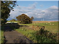
Road at Over Carswell farm
Over Carswell farm road with its white painted fencing meets the Moyne Moor public road just past the trees, where the far sign can be spotted.
Image: © Alec MacKinnon
Taken: 17 Sep 2017
0.24 miles
3
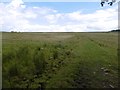
Hill pasture
Looking towards Dun Moss from the hill road between Dunlop and Neilston.
Image: © Richard Webb
Taken: 25 Jun 2016
0.25 miles