IMAGES TAKEN NEAR TO
Neilston, GLASGOW, G78 3DE
Introduction
This page details the photographs taken nearby to G78 3DE by members of the Geograph project.
The Geograph project started in 2005 with the aim of publishing, organising and preserving representative images for every square kilometre of Great Britain, Ireland and the Isle of Man.

There are currently over 7.5m images from over14,400 individuals and you can help contribute to the project by visiting https://www.geograph.org.uk
Image Map
Images are licensed for reuse under creativecommons.org/licenses/by-sa/2.0
Notes
- Clicking on the map will re-center to the selected point.
- The higher the marker number, the further away the image location is from the centre of the postcode.
Image Listing (7 Images Found)
Images are licensed for reuse under creativecommons.org/licenses/by-sa/2.0
Image
Details
Distance
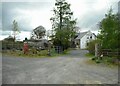
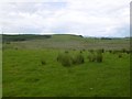
2
Picketlaw Farm
On the minor road between Harelaw and Gabroc Hill.
Image: © Finlay Tindall
Taken: 29 Sep 2006
0.06 miles
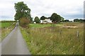
4
Minor road,Moyne Moor
Road cuts through very rough grazing near Picketlaw Farm
Image: © wfmillar
Taken: 19 Oct 2011
0.12 miles
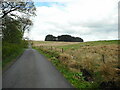
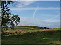
5
Graystonehill
Hill pasture between Neilston and Dunlop.
Image: © Richard Webb
Taken: 25 Jun 2016
0.12 miles
6
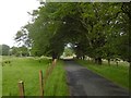
Hill road between Neilston and Dunlop
Near Greystonehill.
Image: © Richard Webb
Taken: 25 Jun 2016
0.13 miles
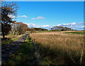
7
Fields near Picketlaw
We look north over the farmland just north of the house at Picketlaw.
Image: © Alec MacKinnon
Taken: 17 Sep 2017
0.14 miles