IMAGES TAKEN NEAR TO
Muirhead Road, GLASGOW, G78 3BX
Introduction
This page details the photographs taken nearby to Muirhead Road, G78 3BX by members of the Geograph project.
The Geograph project started in 2005 with the aim of publishing, organising and preserving representative images for every square kilometre of Great Britain, Ireland and the Isle of Man.

There are currently over 7.5m images from over14,400 individuals and you can help contribute to the project by visiting https://www.geograph.org.uk
Image Map
Images are licensed for reuse under creativecommons.org/licenses/by-sa/2.0
Notes
- Clicking on the map will re-center to the selected point.
- The higher the marker number, the further away the image location is from the centre of the postcode.
Image Listing (7 Images Found)
Images are licensed for reuse under creativecommons.org/licenses/by-sa/2.0
Image
Details
Distance
2
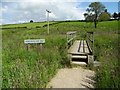
Bridge over Levern Water
The new Neilstonside Path crosses the Levern Water here on its route through a new plantation. Nice for pedestrians but not so easy for prams or wheelchairs.
Image: © Marion Boyle
Taken: 29 Jun 2011
0.10 miles
5
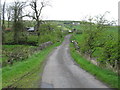
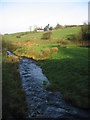
Bridge over the Levern Water
On a minor road north of Commore Dam.
Image: © G Laird
Taken: 2 May 2014
0.19 miles
6
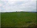
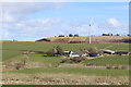
Field, Neilstonside
Hilltop improved pasture, contrasting with the usual rashy upland rough grazing nearby.
Image: © Richard Webb
Taken: 28 Aug 2016
0.21 miles
7
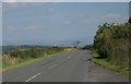
Looking towards Glasgow
Buildings at the western side of Glasgow are visible in the distance. The Campsie Fells can just be seen through the haze.
Image: © Richard Sutcliffe
Taken: 16 Aug 2016
0.24 miles