IMAGES TAKEN NEAR TO
Neilston, GLASGOW, G78 3BH
Introduction
This page details the photographs taken nearby to G78 3BH by members of the Geograph project.
The Geograph project started in 2005 with the aim of publishing, organising and preserving representative images for every square kilometre of Great Britain, Ireland and the Isle of Man.

There are currently over 7.5m images from over14,400 individuals and you can help contribute to the project by visiting https://www.geograph.org.uk
Image Map
Images are licensed for reuse under creativecommons.org/licenses/by-sa/2.0
Notes
- Clicking on the map will re-center to the selected point.
- The higher the marker number, the further away the image location is from the centre of the postcode.
Image Listing (19 Images Found)
Images are licensed for reuse under creativecommons.org/licenses/by-sa/2.0
Image
Details
Distance
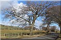
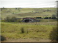
2
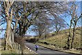
Horseshoe on a post
Near Cowdenmoor Farm.
Image: © James Allan
Taken: 19 Sep 2009
0.02 miles
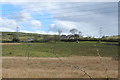
4
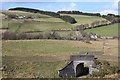
Old railway bridge
Uplawmoor Road crosses the former Lanarkshire and Ayrshire Railway near Shillford. The line closed here in 1962.
Image: © Richard Sutcliffe
Taken: 23 Feb 2023
0.07 miles
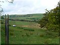
5
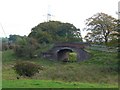
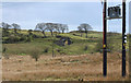
The railway's gone
Bridge carrying a minor road across an long-vanished railway track.
Image: © James Allan
Taken: 19 Sep 2009
0.08 miles