IMAGES TAKEN NEAR TO
Neilston, GLASGOW, G78 3BE
Introduction
This page details the photographs taken nearby to G78 3BE by members of the Geograph project.
The Geograph project started in 2005 with the aim of publishing, organising and preserving representative images for every square kilometre of Great Britain, Ireland and the Isle of Man.

There are currently over 7.5m images from over14,400 individuals and you can help contribute to the project by visiting https://www.geograph.org.uk
Image Map
Images are licensed for reuse under creativecommons.org/licenses/by-sa/2.0
Notes
- Clicking on the map will re-center to the selected point.
- The higher the marker number, the further away the image location is from the centre of the postcode.
Image Listing (29 Images Found)
Images are licensed for reuse under creativecommons.org/licenses/by-sa/2.0
Image
Details
Distance
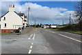
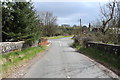
1
Woodend Cottage
At the crossroads at Shillford.
Image: © Richard Sutcliffe
Taken: 23 Feb 2023
0.00 miles
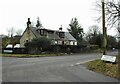
4
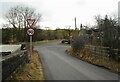
Crossroads at Shillford
Fereneze Road meats the A736, Lochlibo Road. Opposite is Lagavulin Road.
Image: © Richard Sutcliffe
Taken: 23 Feb 2023
0.01 miles
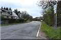
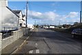
5
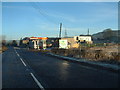
Shillford filling station
Petrol station on the A736 between Barrhead and Lugton
Image: © James Allan
Taken: 25 Dec 2005
0.02 miles
6
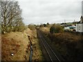
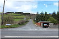
Railway line at Shillford
Looking east along the Glasgow to Dumfries line.
Image: © Richard Sutcliffe
Taken: 23 Feb 2023
0.02 miles
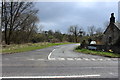
9
A736, Shillford
The Neilston to Stewarton road at a crossroads.
Image: © Richard Webb
Taken: 6 Nov 2016
0.03 miles