IMAGES TAKEN NEAR TO
Neilston, GLASGOW, G78 3AS
Introduction
This page details the photographs taken nearby to G78 3AS by members of the Geograph project.
The Geograph project started in 2005 with the aim of publishing, organising and preserving representative images for every square kilometre of Great Britain, Ireland and the Isle of Man.

There are currently over 7.5m images from over14,400 individuals and you can help contribute to the project by visiting https://www.geograph.org.uk
Image Map
Images are licensed for reuse under creativecommons.org/licenses/by-sa/2.0
Notes
- Clicking on the map will re-center to the selected point.
- The higher the marker number, the further away the image location is from the centre of the postcode.
Image Listing (6 Images Found)
Images are licensed for reuse under creativecommons.org/licenses/by-sa/2.0
Image
Details
Distance
2
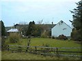
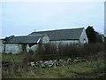
Plymuir farm
The farmhouse and garden at Plymuir.
Image: © James Allan
Taken: 25 Dec 2008
0.03 miles
3
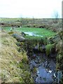
Weed-choked pond
A weir on a burn at Plymuir Farm.
Image: © James Allan
Taken: 25 Dec 2008
0.06 miles
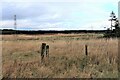
5
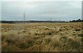
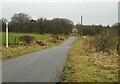
Rough grassland and pylons
Some of the many pylons in the area, carrying power lines to and from the Neilston Electricity Substation.
Image: © Richard Sutcliffe
Taken: 23 Feb 2023
0.17 miles