IMAGES TAKEN NEAR TO
Neilston, GLASGOW, G78 3AQ
Introduction
This page details the photographs taken nearby to G78 3AQ by members of the Geograph project.
The Geograph project started in 2005 with the aim of publishing, organising and preserving representative images for every square kilometre of Great Britain, Ireland and the Isle of Man.

There are currently over 7.5m images from over14,400 individuals and you can help contribute to the project by visiting https://www.geograph.org.uk
Image Map
Images are licensed for reuse under creativecommons.org/licenses/by-sa/2.0
Notes
- Clicking on the map will re-center to the selected point.
- The higher the marker number, the further away the image location is from the centre of the postcode.
Image Listing (8 Images Found)
Images are licensed for reuse under creativecommons.org/licenses/by-sa/2.0
Image
Details
Distance
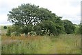
1
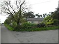
Rural road junction in Lochliboside Hills
At Foreside.
Image: © Stephen Sweeney
Taken: 29 May 2014
0.00 miles

5
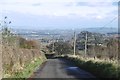
Fereneze Road
Now with trees on either side. A big view over Glasgow.
Image: © Richard Webb
Taken: 6 Nov 2016
0.18 miles
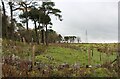
7
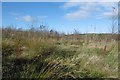
Young woodland, Foreside
Recently planted trees beside Fereneze Road.
Image: © Richard Webb
Taken: 6 Nov 2016
0.19 miles
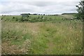
8
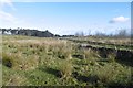
Fereneze Road
On high ground above Neilston.
Image: © Richard Webb
Taken: 6 Nov 2016
0.24 miles