IMAGES TAKEN NEAR TO
Caplaw Road, GLASGOW, G78 3AN
Introduction
This page details the photographs taken nearby to Caplaw Road, G78 3AN by members of the Geograph project.
The Geograph project started in 2005 with the aim of publishing, organising and preserving representative images for every square kilometre of Great Britain, Ireland and the Isle of Man.

There are currently over 7.5m images from over14,400 individuals and you can help contribute to the project by visiting https://www.geograph.org.uk
Image Map
Images are licensed for reuse under creativecommons.org/licenses/by-sa/2.0
Notes
- Clicking on the map will re-center to the selected point.
- The higher the marker number, the further away the image location is from the centre of the postcode.
Image Listing (10 Images Found)
Images are licensed for reuse under creativecommons.org/licenses/by-sa/2.0
Image
Details
Distance
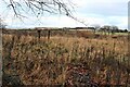
4
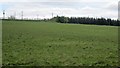
Caplaw
Field between Caplaw and the B775.
Image: © Richard Webb
Taken: 21 May 2013
0.11 miles
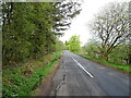
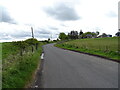
6
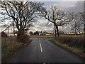
Junction on the B775
Taken from the minor road from Corseford which crosses the B775 leading past Caplaw Farm.
Image: © wfmillar
Taken: 15 Nov 2009
0.15 miles
7
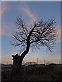
Silhouetted Tree, Gleniffer Braes
November skyline at dusk. This tree has been through the wars. Pylons in the background are from the Electrical Sub Station that dominates these parts.
Image: © wfmillar
Taken: 15 Nov 2009
0.17 miles
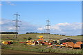
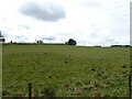
8
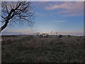
Gleniffer Braes at Dusk
Looking over the moorland towards the Electrical Sub Station If you want to see pylons this is the place for you. The B775 on the right.
Image: © wfmillar
Taken: 15 Nov 2009
0.19 miles