IMAGES TAKEN NEAR TO
Neilston, GLASGOW, G78 3AH
Introduction
This page details the photographs taken nearby to G78 3AH by members of the Geograph project.
The Geograph project started in 2005 with the aim of publishing, organising and preserving representative images for every square kilometre of Great Britain, Ireland and the Isle of Man.

There are currently over 7.5m images from over14,400 individuals and you can help contribute to the project by visiting https://www.geograph.org.uk
Image Map
Images are licensed for reuse under creativecommons.org/licenses/by-sa/2.0
Notes
- Clicking on the map will re-center to the selected point.
- The higher the marker number, the further away the image location is from the centre of the postcode.
Image Listing (8 Images Found)
Images are licensed for reuse under creativecommons.org/licenses/by-sa/2.0
Image
Details
Distance
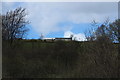
3
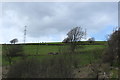
Fereneze Road
Looking towards Neilston with Glasgow beyond.
Image: © wfmillar
Taken: 15 Nov 2009
0.12 miles
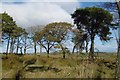
4
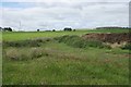
View from Fereneze Road
Looking south towards Braeface Farm across the valley. The wind turbines in the distance are just west of Commore Dam.
Image: © Richard Sutcliffe
Taken: 14 Jul 2017
0.13 miles
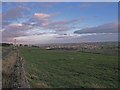
6
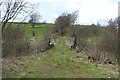
Dung heap and nettles
The dung heap sits on an area of concrete at the corner of the field - possibly laid for that purpose.
Image: © Richard Sutcliffe
Taken: 14 Jul 2017
0.22 miles
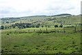
8
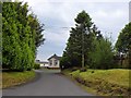
Heatherbank Park
A community in East Renfrewshire for the retired and semi-retired.
Image: © Stephen Sweeney
Taken: 29 May 2014
0.25 miles