IMAGES TAKEN NEAR TO
Springfield Road, GLASGOW, G78 2SG
Introduction
This page details the photographs taken nearby to Springfield Road, G78 2SG by members of the Geograph project.
The Geograph project started in 2005 with the aim of publishing, organising and preserving representative images for every square kilometre of Great Britain, Ireland and the Isle of Man.

There are currently over 7.5m images from over14,400 individuals and you can help contribute to the project by visiting https://www.geograph.org.uk
Image Map
Images are licensed for reuse under creativecommons.org/licenses/by-sa/2.0
Notes
- Clicking on the map will re-center to the selected point.
- The higher the marker number, the further away the image location is from the centre of the postcode.
Image Listing (21 Images Found)
Images are licensed for reuse under creativecommons.org/licenses/by-sa/2.0
Image
Details
Distance
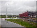
1
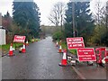
Springfield Road
Closed for a huge building site to the south. Closing the bridge over the deep Aurs Glen to pedestrian traffic was just mean.
Image: © Richard Webb
Taken: 27 Apr 2021
0.03 miles
2
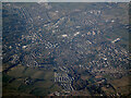
Barrhead from the air
Looking north over the town from a Prague bound flight from Glasgow.
Image: © Thomas Nugent
Taken: 27 Mar 2022
0.08 miles
3
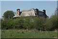
Rock Mount
Big house off Springfield Road, Barrhead.
Image: © Richard Sutcliffe
Taken: 9 May 2016
0.08 miles
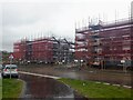
4
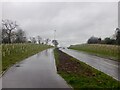
Balgraystone Road
Widened as part of large scale housing development in the area.
Image: © Richard Webb
Taken: 27 Apr 2021
0.11 miles
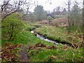
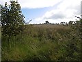
5
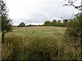
Abandoned farmland, Springhill
Several fields on the edge of Barrhead have not seen grazing nor blade for a few years now. Probably on the books of a house builder.
----
2021: House building in full swing and Springfield Road closed. I got through to St Lukes on foot through the woods of Springhill Dean. Cross the dean just upstream of the viaduct.
Image: © Richard Webb
Taken: 25 Sep 2015
0.12 miles
6
Abandoned farmland, Springhill
Hedges gone, fields overgrown - there is a large area of non farmed farmland here awaiting development.
Image: © Richard Webb
Taken: 25 Sep 2015
0.14 miles
7
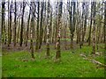
Woodland, north of Springfield Road
Almost surrounded by new houses, and building sites.
Image: © Richard Webb
Taken: 27 Apr 2021
0.16 miles